
Thank you for supporting this site ❤️
Make a donation
Make a donation
Davao Region topographic map
Click on the map to display elevation.
Thank you for supporting this site ❤️
Make a donation
Make a donation
About this map
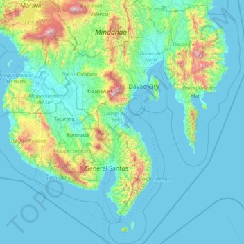
Name: Davao Region topographic map, elevation, terrain.
Location: Davao Region, Philippines (5.22969 125.05220 8.06460 126.73869)
Average elevation: 248 m
Minimum elevation: -1 m
Maximum elevation: 2,763 m
Thank you for supporting this site ❤️
Make a donation
Make a donation
Other topographic maps
Click on a map to view its topography, its elevation and its terrain.
Thank you for supporting this site ❤️
Make a donation
Make a donation
Thank you for supporting this site ❤️
Make a donation
Make a donation
Thank you for supporting this site ❤️
Make a donation
Make a donation
Santa
Philippines > Ilocos Sur > Santa
The topography of the municipality is undulating to rolling with slope ranging from 0-30%.
Average elevation: 75 m
Thank you for supporting this site ❤️
Make a donation
Make a donation