
Make a donation
Gansu topographic map
Click on the map to display elevation.
Make a donation
Gansu
Gansu generally has a semi-arid to arid continental climate (Köppen BSk or BWk) with warm to hot summers and cold to very cold winters, although diurnal temperature ranges are often so large that maxima remain above 0 °C (32 °F) even in winter. However, due to extreme altitude, some areas of Gansu exhibit a subarctic climate (Dwc) – with winter temperatures sometimes dropping to −40 °C (−40 °F). Most of the limited precipitation is delivered in the summer months: winters are so dry that snow cover is confined to very high altitudes and the snow line can be as high as 5,500 metres (18,040 ft) in the southwest.
Make a donation
About this map
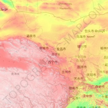
Name: Gansu topographic map, elevation, terrain.
Location: Gansu, China (32.59871 92.33865 42.79457 108.71053)
Average elevation: 2,260 m
Minimum elevation: 288 m
Maximum elevation: 6,009 m
Make a donation
Other topographic maps
Click on a map to view its topography, its elevation and its terrain.
Beijing
Beijing is situated at the northern tip of the roughly triangular North China Plain, which opens to the south and east of the city. Mountains to the north, northwest and west shield the city and northern China's agricultural heartland from the encroaching desert steppes. The northwestern part of the…
Average elevation: 47 m
Chongqing
The central urban area of Chongqing, or Chongqing proper, is a city of unique features. Built on mountains and partially surrounded by the Yangtze and Jialing rivers, it is known as a "mountain city" and a "city on rivers". The night scene of the city is very illuminated, with millions of lights and their…
Average elevation: 318 m
Make a donation
Mount Everest
China > Tibet > Qutang > Khumjung
Mount Everest (Chinese: 珠穆朗玛 Zhūmùlǎngmǎ; Nepali: सगरमाथा Sagarmāthā; Tibetan: Chomolungma ཇོ་མོ་གླང་མ) is Earth's highest mountain above sea level, located in the Mahalangur Himal sub-range of the Himalayas. The China–Nepal border runs across its summit…
Average elevation: 7,839 m