
Uttar Pradesh topographic map
Interactive map
Click on the map to display elevation.
About this map
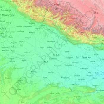
Name: Uttar Pradesh topographic map, elevation, terrain.
Location: Uttar Pradesh, India (23.87063 77.08388 30.40638 84.63451)
Average elevation: 954 m
Minimum elevation: 47 m
Maximum elevation: 7,878 m
Uttar Pradesh, with a total area of 243,290 square kilometres (93,935 sq mi), is India's fourth-largest state in terms of land area and is roughly of same size as United Kingdom. It is situated on the northern spout of India and shares an international boundary with Nepal. The Himalayas border the state on the north, but the plains that cover most of the state are distinctly different from those high mountains. The larger Gangetic Plain region is in the north; it includes the Ganges-Yamuna Doab, the Ghaghra plains, the Ganges plains and the Terai. The smaller Vindhya Range and plateau region are in the south. It is characterised by hard rock strata and a varied topography of hills, plains, valleys and plateaus. The Bhabhar tract gives place to the terai area which is covered with tall elephant grass and thick forests interspersed with marshes and swamps. The sluggish rivers of the bhabhar deepen in this area, their course running through a tangled mass of thick undergrowth. The terai runs parallel to the bhabhar in a thin strip. The entire alluvial plain is divided into three sub-regions. The first in the eastern tract consisting of 14 districts which are subject to periodical floods and droughts and have been classified as scarcity areas. These districts have the highest density of population which gives the lowest per capita land. The other two regions, the central and the western, are comparatively better with a well-developed irrigation system. They suffer from waterlogging and large-scale user tracts. In addition, the area is fairly arid. The state has more than 32 large and small rivers; of them, the Ganga, Yamuna, Saraswati, Sarayu, Betwa, and Ghaghara are larger and of religious importance in Hinduism.
Other topographic maps
Click on a map to view its topography, its elevation and its terrain.
Hyderabad
India > Telangana > Bahadurpura mandal
Hyderabad, Bahadurpura mandal, Hyderabad District, Telangana, India
Average elevation: 549 m
Kargil Tehsil
Kargil Tehsil, Kargil district, Ladakh, 194103, India
Average elevation: 4,005 m
Pithoragarh
India > Uttarakhand > Pithoragarh
Pithoragarh, Uttarakhand, 262500, India
Average elevation: 1,618 m
Yanam
India > Puducherry > Yanam
Yanam, Yanam Taluk, Yanam District, Puducherry, 533464, India
Average elevation: 5 m
Howrah
India > West Bengal > Howrah
Howrah, Haora, Howrah, West Bengal, 711101, India
Average elevation: 5 m
Dharasuram
India > Tamil Nadu > Dharasuram
Dharasuram, Thanjavur district, Tamil Nadu, 612001, India
Average elevation: 28 m
Mansarovar
India > Gujarat > Mansarovar
Mansarovar, Becharaji Taluka, Mahesana District, Gujarat, 384210, India
Average elevation: 46 m
Turiya
India > Madhya Pradesh > Turiya
Turiya, Kurai Tahsil, Seoni, Madhya Pradesh, India
Average elevation: 428 m
Adirampattinam
India > Tamil Nadu > Adirampattinam
Adirampattinam, Thanjavur district, Tamil Nadu, 614701, India
Average elevation: 5 m
Chinchwad
India > Maharashtra > Chinchwad
Chinchwad, Kolhapur, Maharashtra, 416112, India
Average elevation: 548 m
Sarkaghat
India > Himachal Pradesh > Sarkaghat
Sarkaghat, Hamirpur, Himachal Pradesh, 175024, India
Average elevation: 1,014 m
Central Zone
India > Tamil Nadu > Nanjundapuram
Central Zone, Nanjundapuram, Coimbatore district, Tamil Nadu, 641045, India
Average elevation: 399 m
Gurudev Nagar
India > Telangana > Gurudev Nagar
Gurudev Nagar, Boath mandal, Adilabad, Telangana, India
Average elevation: 467 m
New Town
India > West Bengal > New Town
New Town, Twenty-four Parganas, North 24 Parganas, West Bengal, 700161, India
Average elevation: 3 m
Karjat
India > Maharashtra > Karjat
Karjat, Kulāba, Raigad, Maharashtra, 410201, India
Average elevation: 109 m
Kamalapura
India > Karnataka > Kamalapura
Kamalapura, Hosapete taluk, Bellary district, Karnataka, 583221, India
Average elevation: 456 m
Udhagamandalam
India > Tamil Nadu > Udhagamandalam
Udhagamandalam, The Nilgiris, The Nilgiris district, Tamil Nadu, 643001, India
Average elevation: 2,234 m
Sonamarg
India > Jammu and Kashmir > Sonamarg
Sonamarg, Ganderbal, Jammu and Kashmir, India
Average elevation: 3,354 m