
Pithoragarh topographic map
Interactive map
Click on the map to display elevation.
About this map
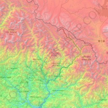
Name: Pithoragarh topographic map, elevation, terrain.
Location: Pithoragarh, Uttarakhand, India (29.44403 79.82155 30.80902 81.04479)
Average elevation: 3,533 m
Minimum elevation: 486 m
Maximum elevation: 7,719 m
Fifteen kilometres from Pithoragarh near Totanaula, there is a mountain called Dhwaj, elevation 2134 m. It is an abode of Goddess Jayanti or Durga and Lord Shiva, atop the hill. Hindu legends tell that at this place 'Chanda and Munda' demons were killed by Devi. Dense forest about the mountain is considered sacred and sacrosanct, so it is in an excellent state of conserved biome with a large number of endemic plants.
Other topographic maps
Click on a map to view its topography, its elevation and its terrain.
Milam Glacier
Milam Glacier, Pithoragarh, Uttarakhand, India
Average elevation: 5,223 m
Pindar Glacier
Pindar Glacier, Bageshwar, Uttarakhand, India
Average elevation: 4,447 m
Pithoragarh
India > Uttarakhand > Pithoragarh
Pithoragarh, Uttarakhand, 262500, India
Average elevation: 1,618 m