
Haryana topographic map
Interactive map
Click on the map to display elevation.
About this map
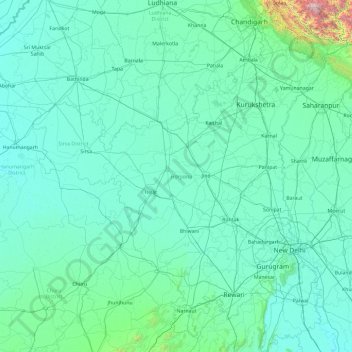
Name: Haryana topographic map, elevation, terrain.
Location: Haryana, India (27.65263 74.47351 30.92877 77.60214)
Average elevation: 281 m
Minimum elevation: 169 m
Maximum elevation: 3,601 m
Haryana is a landlocked state in northern India. It is between 27°39' to 30°35' N latitude and between 74°28' and 77°36' E longitude. The total geographical area of the state is 4.42 m ha, which is 1.4% of the geographical area of the country. The altitude of Haryana varies between 700 and 3600 ft (200 metres to 1200 metres) above sea level. Haryana has only 4% (compared with national 21.85%) area under forests. Karoh Peak, a 1,467-metre (4,813 ft) tall mountain peak in the Sivalik Hills range of the greater Himalayas range located near Morni Hills area of Panchkula district, is the highest point in Haryana. Most of the state sits atop the fertile Ghaggar Plain, a subsection of the Indo-Gangetic Plain. Haryana has 4 states and 2 union territories on its border – Punjab, Rajasthan, Uttar Pradesh, Himachal Pradesh, Delhi, and Chandigarh.
Other topographic maps
Click on a map to view its topography, its elevation and its terrain.
Hyderabad
India > Telangana > Bahadurpura mandal
Hyderabad, Bahadurpura mandal, Hyderabad District, Telangana, India
Average elevation: 549 m
Kargil Tehsil
Kargil Tehsil, Kargil district, Ladakh, 194103, India
Average elevation: 4,005 m
Yanam
India > Puducherry > Yanam
Yanam, Yanam Taluk, Yanam District, Puducherry, 533464, India
Average elevation: 5 m
Howrah
India > West Bengal > Howrah
Howrah, Haora, Howrah, West Bengal, 711101, India
Average elevation: 5 m
Dharasuram
India > Tamil Nadu > Dharasuram
Dharasuram, Thanjavur district, Tamil Nadu, 612001, India
Average elevation: 28 m
Mansarovar
India > Gujarat > Mansarovar
Mansarovar, Becharaji Taluka, Mahesana District, Gujarat, 384210, India
Average elevation: 46 m
Turiya
India > Madhya Pradesh > Turiya
Turiya, Kurai Tahsil, Seoni, Madhya Pradesh, India
Average elevation: 428 m
Adirampattinam
India > Tamil Nadu > Adirampattinam
Adirampattinam, Thanjavur district, Tamil Nadu, 614701, India
Average elevation: 5 m
Chinchwad
India > Maharashtra > Chinchwad
Chinchwad, Kolhapur, Maharashtra, 416112, India
Average elevation: 548 m
Sarkaghat
India > Himachal Pradesh > Sarkaghat
Sarkaghat, Hamirpur, Himachal Pradesh, 175024, India
Average elevation: 1,014 m
Central Zone
India > Tamil Nadu > Nanjundapuram
Central Zone, Nanjundapuram, Coimbatore district, Tamil Nadu, 641045, India
Average elevation: 399 m
Gurudev Nagar
India > Telangana > Gurudev Nagar
Gurudev Nagar, Boath mandal, Adilabad, Telangana, India
Average elevation: 467 m
New Town
India > West Bengal > New Town
New Town, Twenty-four Parganas, North 24 Parganas, West Bengal, 700161, India
Average elevation: 3 m
Karjat
India > Maharashtra > Karjat
Karjat, Kulāba, Raigad, Maharashtra, 410201, India
Average elevation: 109 m
Kamalapura
India > Karnataka > Kamalapura
Kamalapura, Hosapete taluk, Bellary district, Karnataka, 583221, India
Average elevation: 456 m
Udhagamandalam
India > Tamil Nadu > Udhagamandalam
Udhagamandalam, The Nilgiris, The Nilgiris district, Tamil Nadu, 643001, India
Average elevation: 2,234 m
Sonamarg
India > Jammu and Kashmir > Sonamarg
Sonamarg, Ganderbal, Jammu and Kashmir, India
Average elevation: 3,354 m
Tso Moriri
Tso Moriri, Leh District, Jammu and Kashmir, India
Average elevation: 5,044 m