
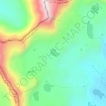
Gladys Lake topographic map
Interactive map
Click on the map to display elevation.
About this map
Name: Gladys Lake topographic map, elevation, terrain.
Average elevation: 3,385 m
Minimum elevation: 3,165 m
Maximum elevation: 3,828 m
Other topographic maps
Click on a map to view its topography, its elevation and its terrain.
Canyonlands National Park - Maze District
Canyonlands National Park - Maze District, White Rim Road, San Juan County, Utah, USA
Average elevation: 1,546 m
Long Valley Junction
USA > Utah > Long Valley Junction
Long Valley Junction, Kane County, Utah, 84710, USA
Average elevation: 2,295 m
Thousand Lake Mountain
Thousand Lake Mountain, Wayne County, Utah, USA
Average elevation: 3,341 m
Haystack Lake
Haystack Lake, Lakes Country Trail, Summit County, Utah, USA
Average elevation: 3,067 m
Capitol Hill
USA > Utah > Salt Lake City
Capitol Hill, Salt Lake City, Salt Lake County, Utah, 84103, USA
Average elevation: 1,510 m
La Sal Mountains Viewpoint
La Sal Mountains Viewpoint, Arches Entrance Road, Grand County, Utah, 84532-2134, USA
Average elevation: 1,347 m
Browns Park
Browns Park, Bountiful, Davis County, Utah, 84010, USA
Average elevation: 1,556 m
Timpanogos Glacier
USA > Utah > Aspen Grove
Timpanogos Glacier, Mount Timpanogos Trail #052, Aspen Grove, Utah County, Utah, USA
Average elevation: 3,148 m
Little Bear River
Little Bear River, Cache County, Utah, 84319, USA
Average elevation: 1,475 m