
Make a donation
Northern Territory topographic map
Click on the map to display elevation.
Make a donation
Northern Territory
The fatigue resulting from long-distance driving and the hazards inherent in dirt roads, wildlife, water crossings and wild weather have led the Northern Territory Government to pursue road safety campaigns in English and several Aboriginal languages. Persuading people to drive at the right speed for the road conditions has been a key goal. As of 2021, the Northern Territory's road vehicle speed limit in built-up areas was 60 kilometres per hour unless the town had gazetted a lower default speed limit: many had chosen 50 km/h or lower. Outside most built-up areas the default speed limit was 110 km/h unless a speed limit sign stated otherwise. Reflecting the nature of the topography and very low population density, some sections of the Arnhem, Barkly, Stuart and Victoria highways had a maximum speed of 130 km/h.
Make a donation
About this map
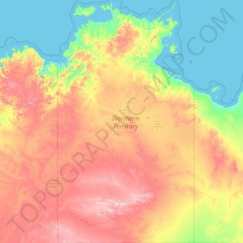
Name: Northern Territory topographic map, elevation, terrain.
Location: Northern Territory, Australia (-25.99862 129.00045 -10.85246 138.02737)
Average elevation: 230 m
Minimum elevation: -1 m
Maximum elevation: 1,123 m
Make a donation
Other topographic maps
Click on a map to view its topography, its elevation and its terrain.
Sydney
Australia > New South Wales > Sydney
The Hills district generally refers to the suburbs in north-western Sydney including the local government areas of The Hills Shire, parts of the City of Parramatta Council and Hornsby Shire. Actual suburbs and localities that are considered to be in the Hills District can be somewhat amorphous and variable.…
Average elevation: 32 m
Make a donation