
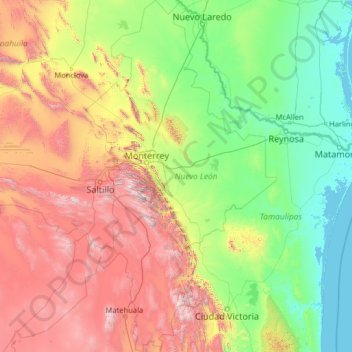
Nuevo León topographic map
Interactive map
Click on the map to display elevation.
About this map
Name: Nuevo León topographic map, elevation, terrain.
Location: Nuevo León, Mexico (23.16267 -101.20676 27.79914 -98.42158)
Average elevation: 805 m
Minimum elevation: -2 m
Maximum elevation: 3,623 m
Nuevo León's geography is known for englobing three of the most important physiographic provinces of the northeast region. The south end of the Great Plains is considered to start in the northernmost regions of Nuevo León. The region is characterized by the soft hills that dominates the lands neighboring the banks of the Rio Grande. The south and west of the state consists of the Sierra Madre Oriental mountain range, which dominates most of the western scenery. Due to the abrupt shape of the mountains, there are vast valleys in between the mountains. Within these valleys is where the city of Monterrey and its metropolitan area is situated. The Northern Gulf Coastal Plains are located to the east and include low altitude lands; it is classified as an "inclined plain" due to the alluvial land.
Other topographic maps
Click on a map to view its topography, its elevation and its terrain.
Cabo San Lucas
Mexico > Baja California Sur > Los Cabos Municipality
Cabo San Lucas, Los Cabos Municipality, Baja California Sur, 23470, Mexico
Average elevation: 94 m
Papagayo
Mexico > Yucatán > Valladolid
Papagayo, Valladolid, Yucatán, 97783, Mexico
Average elevation: 21 m
Acapulco
Mexico > Guerrero > Acapulco de Juárez
Acapulco, Acapulco de Juárez, Guerrero, 39300, Mexico
Average elevation: 99 m
Sian Ka'an
Mexico > Quintana Roo > Punta Allen
Sian Ka'an, Carretera Tulum - Punta Allen, Punta Allen, Tulum, Quintana Roo, Mexico
Average elevation: 4 m
San Martin Cuautlalpan
Mexico > Mexico > San Martin Cuautlalpan
San Martin Cuautlalpan, Chalco, Mexico, 56643, Mexico
Average elevation: 2,323 m
Los Ángeles
Mexico > Querétaro > Los Ángeles
Los Ángeles, Corregidora, Querétaro, 76927, Mexico
Average elevation: 1,854 m
San Nicolás de los Garza
Mexico > Nuevo León > San Nicolás de los Garza
San Nicolás de los Garza, Nuevo León, 66443, Mexico
Average elevation: 584 m
Mexicali
Mexico > Baja California > Mexicali
Mexicali, Baja California, 21000, Mexico
Average elevation: 18 m
Noria de los Gringos
Mexico > Zacatecas > Noria de los Gringos
Noria de los Gringos, Morelos, Zacatecas, Mexico
Average elevation: 2,205 m
San Felipe Nuevo
Mexico > Yucatán > San Felipe Nuevo
San Felipe Nuevo, Tinum, Yucatán, 97751, Mexico
Average elevation: 27 m
Camino Real
Camino Real, Terrenos del Lote Tancoco, Tancoco, Veracruz, Mexico
Average elevation: 534 m
Arcos Vallarta
Mexico > Jalisco > Guadalajara
Arcos Vallarta, Guadalajara, Jalisco, 44130, Mexico
Average elevation: 1,585 m
Tlaquepaque
Mexico > Jalisco > Tlaquepaque
Tlaquepaque, San Pedro Tlaquepaque, Jalisco, 45590, Mexico
Average elevation: 1,567 m
Piedras Negras
Mexico > Coahuila > Piedras Negras
Piedras Negras, Coahuila, Mexico
Average elevation: 236 m
Sierra Madre Oriental
Sierra Madre Oriental, Galeana, Nuevo León, Mexico
Average elevation: 3,072 m
Rio Grande de Santiago
Rio Grande de Santiago, Juanacatlán, Jalisco, 45620, Mexico
Average elevation: 1,481 m
Pico de Orizaba
Pico de Orizaba, Ciudad Serdán, Puebla, Mexico
Average elevation: 4,967 m
San Pedro Garza García
Mexico > Nuevo León > San Pedro Garza García
San Pedro Garza García, Nuevo León, 66210, Mexico
Average elevation: 798 m
Alberca Colegio Inglés
Alberca Colegio Inglés, Acerina, Colima, 28000, Mexico
Average elevation: 585 m
El Chichón
Mexico > Veracruz > El Chichón
El Chichón, Las Choapas, Veracruz, Mexico
Average elevation: 44 m