
Thank you for supporting this site ❤️
Make a donation
Make a donation
Coahuila topographic map
Click on the map to display elevation.
Thank you for supporting this site ❤️
Make a donation
Make a donation
Coahuila
The Sierra Madre Oriental runs northwest to southeast through the State, and the higher elevations are home to the Sierra Madre Oriental pine-oak forests. The northernmost fingers of the Sierra Madre Oriental, the Sierra del Burro and the Sierra del Carmen, reach to the border with the United States at the Rio Grande.
Thank you for supporting this site ❤️
Make a donation
Make a donation
About this map
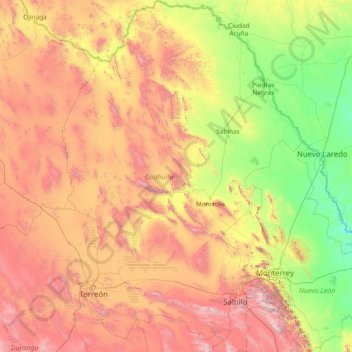
Name: Coahuila topographic map, elevation, terrain.
Location: Coahuila, Mexico (24.54268 -103.96000 29.88003 -99.84288)
Average elevation: 1,009 m
Minimum elevation: 61 m
Maximum elevation: 3,619 m
Thank you for supporting this site ❤️
Make a donation
Make a donation
Other topographic maps
Click on a map to view its topography, its elevation and its terrain.