
Alcollarín topographic map
Interactive map
Click on the map to display elevation.
About this map
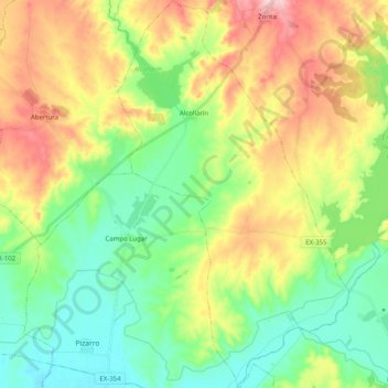
Name: Alcollarín topographic map, elevation, terrain.
Location: Alcollarín, Miajadas, Cáceres, Estrémadure, 10009, Espagne (39.13518 -5.77656 39.29055 -5.65640)
Average elevation: 337 m
Minimum elevation: 268 m
Maximum elevation: 452 m
Other topographic maps
Click on a map to view its topography, its elevation and its terrain.
Zorita
Espagne > Estrémadure > Miajadas
Zorita, Miajadas, Cáceres, Estrémadure, 10130, Espagne
Average elevation: 407 m