
St. Thomas topographic map
Interactive map
Click on the map to display elevation.
About this map
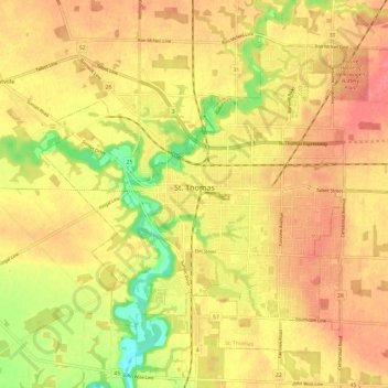
Name: St. Thomas topographic map, elevation, terrain.
Location: St. Thomas, Ontario, Canada (42.74208 -81.24051 42.81294 -81.12042)
Average elevation: 234 m
Minimum elevation: 189 m
Maximum elevation: 260 m
Other topographic maps
Click on a map to view its topography, its elevation and its terrain.
Toledo
Canada > Ontario > Leeds and Grenville Counties > Elizabethtown-Kitley
Average elevation: 121 m