
乌鲁木齐市 topographic map
Interactive map
Click on the map to display elevation.
About this map
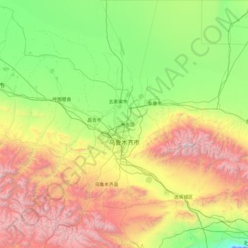
Name: 乌鲁木齐市 topographic map, elevation, terrain.
Location: 乌鲁木齐市, 新疆维吾尔自治区, 中国 (42.92201 86.79397 45.00066 88.97205)
Average elevation: 1,294 m
Minimum elevation: -10 m
Maximum elevation: 5,209 m
Other topographic maps
Click on a map to view its topography, its elevation and its terrain.
塔合曼乡
中国 > 新疆维吾尔自治区 > 塔什库尔干塔吉克自治县 > 塔合曼乡
塔合曼乡, 塔什库尔干塔吉克自治县, 喀什地区, 新疆维吾尔自治区, 中国
Average elevation: 3,146 m