
Cuando Cubango Province topographic map
Interactive map
Click on the map to display elevation.
About this map
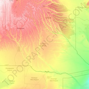
Name: Cuando Cubango Province topographic map, elevation, terrain.
Location: Cuando Cubango Province, Angola (-18.03938 16.46068 -13.56580 23.43423)
Average elevation: 1,201 m
Minimum elevation: 957 m
Maximum elevation: 1,864 m
Other topographic maps
Click on a map to view its topography, its elevation and its terrain.
Luanda Province
Angola > Luanda > Viana Municipality
Luanda Province, Estrada do Zango-Calumbo, Viana Municipality, Luanda, Angola
Average elevation: 112 m