
Chelan County topographic map
Interactive map
Click on the map to display elevation.
About this map
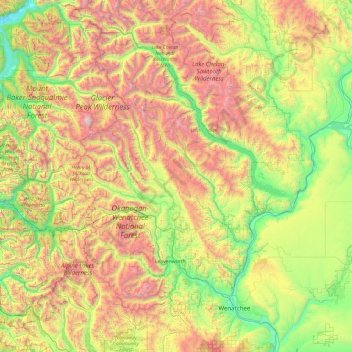
Name: Chelan County topographic map, elevation, terrain.
Location: Chelan County, Washington, United States (47.26087 -121.18071 48.55073 -119.85971)
Average elevation: 1,094 m
Minimum elevation: 72 m
Maximum elevation: 3,185 m
Other topographic maps
Click on a map to view its topography, its elevation and its terrain.
North Bend
United States > Washington > King County
North Bend, King County, Washington, United States
Average elevation: 160 m
Skamania County
Skamania County, Washington, United States
Average elevation: 771 m
Mount Stuart
Mount Stuart, Chelan County, Washington, United States
Average elevation: 2,109 m
Skykomish
United States > Washington > Skykomish
Skykomish, King County, Washington, United States
Average elevation: 441 m
Snohomish County
Snohomish County, Washington, United States
Average elevation: 649 m
Skagit County
Skagit County, Washington, United States
Average elevation: 753 m