
Iligan topographic map
Interactive map
Click on the map to display elevation.
About this map
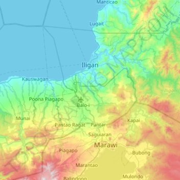
Name: Iligan topographic map, elevation, terrain.
Location: Iligan, Northern Mindanao, 9200, Philippines (8.00300 124.10778 8.33613 124.58131)
Average elevation: 404 m
Minimum elevation: 0 m
Maximum elevation: 1,713 m
Other topographic maps
Click on a map to view its topography, its elevation and its terrain.
Santa
Philippines > Ilocos Sur > Santa
The topography of the municipality is undulating to rolling with slope ranging from 0-30%.
Average elevation: 75 m