
Shirvan topographic map
Interactive map
Click on the map to display elevation.
Shirvan
Throughout its history, Shirvan has suffered from floods because of its proximity to the river and the relatively low elevation of most of the town.
About this map
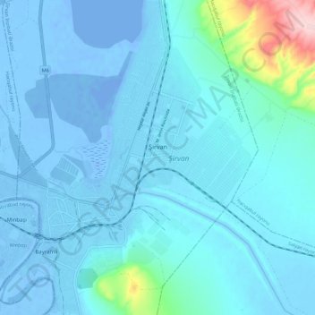
Name: Shirvan topographic map, elevation, terrain.
Location: Shirvan, Shirvan District, 1800, Azerbaijan (39.90947 48.88522 39.99421 48.97853)
Average elevation: 16 m
Minimum elevation: -25 m
Maximum elevation: 251 m
Other topographic maps
Click on a map to view its topography, its elevation and its terrain.
Nakhchivan Autonomous Republic
The Republic is rich in minerals. Nakhchivan possesses deposits of marble, lime, and gypsum. The deposits of the rock salt are exhausted in Nehram, Nakhchivan, and Sustin. The important molybdenum mines are currently closed as a consequence of the exclave's isolation. There are a lot of mineral springs such as…
Average elevation: 1,590 m