
Nakhchivan Autonomous Republic topographic map
Interactive map
Click on the map to display elevation.
About this map
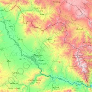
Name: Nakhchivan Autonomous Republic topographic map, elevation, terrain.
Location: Nakhchivan Autonomous Republic, Azerbaijan (38.84452 44.76337 39.79438 46.14971)
Average elevation: 1,590 m
Minimum elevation: 540 m
Maximum elevation: 3,804 m
The Republic is rich in minerals. Nakhchivan possesses deposits of marble, lime, and gypsum. The deposits of the rock salt are exhausted in Nehram, Nakhchivan, and Sustin. The important molybdenum mines are currently closed as a consequence of the exclave's isolation. There are a lot of mineral springs such as Badamli, Sirab, Nagajir, Kiziljir where water contains arsenic. About 90% of the agricultural land is now in private hands. However, agriculture has become a poorly capitalized, backyard activity. Production has dropped sharply and large-scale commercial agriculture has declined. Over two-thirds of the land are rocky slopes and deserts, therefore the area of arable lands is quite limited. The main crops – cotton and tobacco – are cultivated in the PriAraz plain, near Sharur and Nakhchivan City. Three-quarters of the grain production, especially winter wheat is concentrated on the irrigated lands of the Sharur plain and in the basin of the Nakhchivan river. Vine growing in Nakhchivan has an ancient tradition, in the Araz valley and foothills. Very hot summers and long warm autumns make it possible to grow such highly saccharine grapes as bayan-shiraz, tebrizi, shiraz. Wines such as "Nakhchivan" "Shahbuz", "Abrakunis", at "Aznaburk" are of reasonable quality and very popular. Fruit production is quite important, mainly of quince, pear, peach, apricot, fig, almonds, and pomegranate. Cattle ranching is another traditional branch of Nakhchivan farming. Due to the dry climate, pastures in Nakhchivan are unproductive, therefore sheep breeding prevails over other livestock production. Winter pastures stretch on the PriAraz plain, on the foothills and mountainsides to the altitude of 1,200 metres (3,900 ft). But the summer pastures go up on the high-mountain area to an altitude of 2,300–3,200 metres (7,500–10,500 ft). The most widespread sheep variety is "balbas". These sheep are distinguished by their productivity and snow-white silky wool which is widely used in the manufacture of carpets. Horned and small cattle are bred everywhere, especially in the environs of Sharur and Nakhchivan. Buffaloes are also bred here.
Other topographic maps
Click on a map to view its topography, its elevation and its terrain.