
Fox Crossing topographic map
Interactive map
Click on the map to display elevation.
About this map
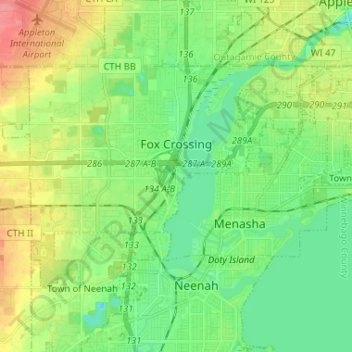
Name: Fox Crossing topographic map, elevation, terrain.
Location: Fox Crossing, Winnebago County, Wisconsin, United States (44.18538 -88.53446 44.24439 -88.40405)
Average elevation: 238 m
Minimum elevation: 213 m
Maximum elevation: 285 m
Other topographic maps
Click on a map to view its topography, its elevation and its terrain.
Town of Nepeuskum
United States > Wisconsin > Winnebago County
Town of Nepeuskum, Winnebago County, Wisconsin, United States
Average elevation: 258 m
Oshkosh
United States > Wisconsin > Winnebago County
Oshkosh, Winnebago County, Wisconsin, United States
Average elevation: 235 m
Winneconne
United States > Wisconsin > Winnebago County
Winneconne, Winnebago County, Wisconsin, 54986, United States
Average elevation: 230 m
Larsen
United States > Wisconsin > Winnebago County
Larsen, Town of Clayton, Winnebago County, Wisconsin, United States
Average elevation: 238 m
Lake Poygan
United States > Wisconsin > Winnebago County
Lake Poygan, Town of Poygan, Winnebago County, Wisconsin, United States
Average elevation: 230 m
Oshkosh
United States > Wisconsin > Winnebago County > Oshkosh
Oshkosh, Winnebago County, Wisconsin, 54903, United States
Average elevation: 239 m
Neenah
United States > Wisconsin > Winnebago County
Neenah, Winnebago County, Wisconsin, 54956, United States
Average elevation: 230 m