
Bald Mountain topographic map
Interactive map
Click on the map to display elevation.
About this map
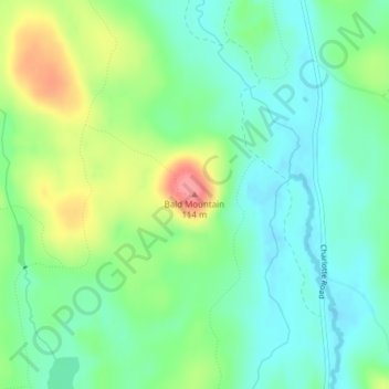
Name: Bald Mountain topographic map, elevation, terrain.
Location: Bald Mountain, Washington County, Maine, USA (45.08808 -67.28782 45.08818 -67.28772)
Average elevation: 63 m
Minimum elevation: 34 m
Maximum elevation: 122 m
Other topographic maps
Click on a map to view its topography, its elevation and its terrain.
Biddeford Pool
USA > Maine > Biddeford Pool
Biddeford Pool, York County, Maine, USA
Average elevation: 0 m
Jordan Harbor
USA > Maine > Gerrishville
Jordan Harbor, Summer Harbor Road, Gerrishville, Hancock County, Maine, 04693, USA
Average elevation: 20 m
Woodland Center
USA > Maine > Woodland Center
Woodland Center, Aroostook County, Maine, USA
Average elevation: 202 m
The Mini Muck
The Mini Muck, Miller Street, Belfast, Waldo County, Maine, 04915-9998, USA
Average elevation: 47 m
Snowshoe Mountain
Snowshoe Mountain, Piscataquis County, Maine, USA
Average elevation: 378 m
Bass Island
USA > Maine > Kennebunkport
Bass Island, Kennebunkport, York County, Maine, USA
Average elevation: 3 m
Turner Island
USA > Maine > South Portland
Turner Island, South Portland, Cumberland County, Maine, 04112, USA
Average elevation: 36 m
Timber Island
Timber Island, Biddeford, York County, Maine, USA
Average elevation: 1 m
Cunningham Mountains
Cunningham Mountains, Penobscot County, Maine, USA
Average elevation: 262 m
Burnt Coat Harbor Lighthouse
USA > Maine > Swans Island
Burnt Coat Harbor Lighthouse, Harbor Road, Swans Island, Hancock County, Maine, 04685, USA
Average elevation: 5 m
Lookout Mountain
Lookout Mountain, Penobscot County, Maine, 04455, USA
Average elevation: 160 m