
Mbale topographic map
Interactive map
Click on the map to display elevation.
About this map
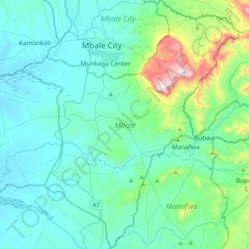
Name: Mbale topographic map, elevation, terrain.
Location: Mbale, Eastern Region, Uganda (0.82909 34.08108 1.12407 34.33765)
Average elevation: 1,266 m
Minimum elevation: 1,076 m
Maximum elevation: 2,336 m
Other topographic maps
Click on a map to view its topography, its elevation and its terrain.