Geolocate

Quezon City topographic map

Interactive map

Click on the map to display elevation.

Quezon City

In order to make Quezon's dream a reality and to mobilize funds for the land purchase, the People's Homesite Corporation (PHC) was created on October 14, 1938, as a subsidiary of NDC, with an initial capital of ₱2 million. Roces was the chairman of the Board of PHC, and they immediately acquired the vast Diliman Estate of the Tuason family at a cost of 5 centavos per square meter. PHC conducted topographical and subdivision surveys, and then subdivided the lots and sold them to the target buyers at an affordable price. Its target users and beneficiaries are obviously Manila's working class, who are suffering from the shortage of affordable and decent housing in the capital. The service of the Metropolitan Waterworks system was extended to site. The Bureau of Public Works, then under Secretary Vicente Fragante, constructed the streets and highways within the property. Quezon also tapped Architect Juan M. Arellano to draft a design of the city.

Wikipedia (CC-BY-SA 3.0)

About this map

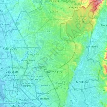
Name: Quezon City topographic map, elevation, terrain.

Location: Quezon City, Eastern Manila District, Metro Manila, 1100, Philippines (14.58937 120.98967 14.77641 121.13383)

Average elevation: 39 m

Minimum elevation: -2 m

Maximum elevation: 252 m

Other topographic maps

Click on a map to view its topography, its elevation and its terrain.

Allen

Philippines > Northern Samar

Average elevation: 33 m

Bato

Philippines > Basilan > Lamitan

Average elevation: 16 m

Dolores

Philippines > Pampanga > Magalang

Average elevation: 41 m

Badiangan

Philippines > Iloilo

Average elevation: 66 m

Barili

Philippines > Cebu

Average elevation: 81 m

Tanza River

Philippines > Navotas

Average elevation: 3 m

Liloan

Philippines > Cebu

Average elevation: 17 m

Bonbonon

Philippines > Bohol

Average elevation: 6 m

Ubay

Philippines > Bohol

Average elevation: 12 m

Tullahan River

Philippines > Quezon City

Average elevation: 58 m

Pasig River

Philippines > Pasig

Average elevation: 14 m

Tangos

Philippines > Tangos

Average elevation: 2 m

Baguio

Philippines > Benguet > Baguio

Average elevation: 882 m

San Pablo

Philippines > Laguna > San Pablo

Average elevation: 220 m

Makati

Philippines > Makati

Average elevation: 26 m

Zone 8

Philippines > Adela Hidalgo Village

Average elevation: 9 m

Tabuelan

Philippines > Cebu > Tabuelan

Average elevation: 40 m

Angat

Philippines > Bulacan > Angat

Average elevation: 52 m

Angat Dam

Philippines > Bulacan > San Jose del Monte

Average elevation: 254 m

Bohol

Philippines > Bohol

Average elevation: 118 m

Bocaue

Philippines > Bulacan > Bocaue

Average elevation: 7 m

Madrid

Philippines > Surigao del Sur > Madrid

Average elevation: 22 m

Santa

Philippines > Ilocos Sur > Santa

The topography of the municipality is undulating to rolling with slope ranging from 0-30%.

Average elevation: 75 m

Tamburok

Philippines > Biliran

Average elevation: 183 m