
Mweru Wantipa National Park topographic map
Interactive map
Click on the map to display elevation.
About this map
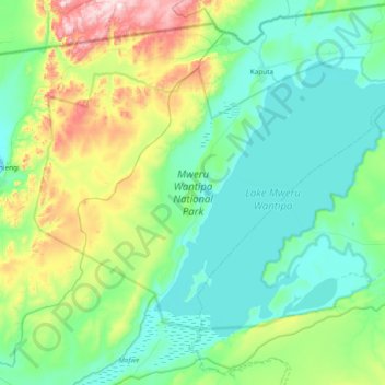
Name: Mweru Wantipa National Park topographic map, elevation, terrain.
Location: Mweru Wantipa National Park, D817, Northern Province, Zambia (-8.97599 29.21284 -8.44462 29.97243)
Average elevation: 1,059 m
Minimum elevation: 921 m
Maximum elevation: 1,619 m
Other topographic maps
Click on a map to view its topography, its elevation and its terrain.
Kasama District
Kasama District, Northern Province, Zambia
Average elevation: 1,299 m
Chilubi Island
Chilubi Island, Northern Province, Zambia
Average elevation: 1,169 m
Kasama
Zambia > Northern Province > Kasama
Kasama, Northern Province, Zambia
Average elevation: 1,363 m
Mungwi
Zambia > Northern Province > Mungwi
Mungwi, Mungwi District, Northern Province, Zambia
Average elevation: 1,376 m
Chambeshi River
Chambeshi River, Northern Province, Zambia
Average elevation: 1,298 m
Isangano National Park
Isangano National Park, Northern Province, Zambia
Average elevation: 1,184 m
Lake Mweru Wantipa
Lake Mweru Wantipa, Northern Province, Zambia
Average elevation: 1,044 m
Sumbu National Park
Sumbu National Park, Northern Province, Zambia
Average elevation: 1,100 m