
Make a donation
Loja topographic map
Click on the map to display elevation.
Make a donation
Loja
Loja is located in a high Andean valley at an elevation of 7,300 feet (2,225 m). It had a population of 448,966 inhabitants at the 2010 census. It is recognized as being a friendly and pleasant city. This was demonstrated when Loja, both the provincial capital and one of the oldest cities in Ecuador, won a community involvement award in 2001 in recognition of the community's ongoing effort to support and to protect the environment.
Make a donation
About this map
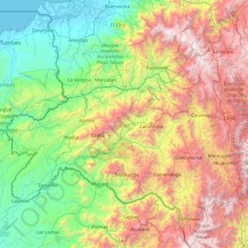
Name: Loja topographic map, elevation, terrain.
Location: Loja, Ecuador (-4.74888 -80.48468 -3.32956 -79.10069)
Average elevation: 1,227 m
Minimum elevation: -3 m
Maximum elevation: 3,850 m
Make a donation
Other topographic maps
Click on a map to view its topography, its elevation and its terrain.
Isla Plaza Sur
Ecuador > Galápagos > Cantón Santa Cruz
South Plaza (Spanish: Isla Plaza Sur) is a small island off the east coast of Santa Cruz in the Galápagos Islands. It has an area of 0.13 km2 and a maximum altitude of 23 metres.
Average elevation: 5 m