
Make a donation
South America topographic map
Click on the map to display elevation.
Make a donation
South America
South America's topography is marked by remarkable diversity and dramatic contrasts. The continent is dominated by the Andes mountain range, which runs along its western edge, stretching over 4,300 miles from Venezuela to Chile. These mountains are home to some of the highest peaks in the Western Hemisphere, including Aconcagua, which rises to 22,841 feet. To the east of the Andes lies the expansive Amazon Basin, encompassing nearly 2.7 million square miles and characterized by dense rainforests that are teeming with biodiversity. The basin is fed by numerous tributaries, including the mighty Amazon River, which discharges vast volumes of water into the Atlantic Ocean. Meanwhile, the eastern regions feature the fertile Pampas, a vast grassland ideal for agriculture, and the semi-arid regions of Patagonia, known for its rugged terrain and sparse rainfall due to the rain shadow effect of the Andes. Notably, the Atacama Desert, situated along the Pacific coast, is recognized as the driest non-polar desert in the world, showcasing the continent's extreme climatic conditions and geographical variety.
Make a donation
About this map
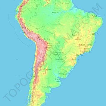
Name: South America topographic map, elevation, terrain.
Location: South America (-46.00022 -86.00066 3.99978 -36.00066)
Average elevation: 283 m
Minimum elevation: -1 m
Maximum elevation: 6,497 m
Make a donation
Other topographic maps
Click on a map to view its topography, its elevation and its terrain.
24401
Germany > Schleswig-Holstein > Kreis Schleswig-Flensburg > Böelschuby > Billwatt
Average elevation: 27 m
Make a donation
Swat
Pakistan > Khyber Pakhtunkhwa > Charsadda District > بانڈہ سیداں > بِجلۍ کورونه
Average elevation: 370 m
Make a donation
Afshan Colony
Pakistan > Punjab > Rawalpindi District > Rawalpindi Cantonment
Average elevation: 518 m
Ayvacık
Ayvacık (Turkish: [ˈajvadʒɯk]) is a town in Çanakkale Province in the Marmara region of Turkey. It is the seat of Ayvacık District. Its population is 9,710 (2021). The town lies at an elevation of 252 m (827 ft). During the Gallipoli campaign in World War I, it was the target of several Allied attacks.
Average elevation: 168 m
Make a donation
Tétouan تطوان
Morocco > Tangier-Tetouan-Al Hoceima > Pachalik de Tétouan باشوية تطوان
Average elevation: 176 m
Make a donation
Make a donation
Bacolod
Bacólod (English: Bacolod), is derived from bakólod (Old Spelling: bacólod), the Old Hiligaynon (Old Ilonggo) (Old Spelling: Ylongo and Ilongo) word for a "hill, turtle, mound, rise, hillock, down, any small eminence or elevation", since the resettlement was founded on a stony, hilly area, now the barangay…
Average elevation: 54 m
Make a donation
Make a donation
Quebec
Quebec's topography is very different from one region to another due to the varying composition of the ground, the climate, and the proximity to water. More than 95% of Quebec's territory, including the Labrador Peninsula, lies within the Canadian Shield. It is generally a quite flat and exposed mountainous…
Average elevation: 195 m
Genoa
The city of Genoa covers an area of 243 square kilometres (94 sq mi) between the Ligurian Sea and the Apennine Mountains. It stretches along the coast for about 30 kilometres (19 mi) from the neighbourhood of Voltri to Nervi, and for 10 kilometres (6.2 mi) from the coast to the north along the valleys…
Average elevation: 333 m
Make a donation
Cashel
The Rock of Cashel, to which the town below owes its origin, is an isolated elevation of stratified limestone, rising abruptly from a broad and fertile plain called the Golden Vale. The top of this eminence is crowned by a group of remarkable ruins. Originally known as Fairy Hill, or Sid-Druim, the Rock was,…
Average elevation: 115 m
M'Hamid El Ghizlane
Morocco > Drâa-Tafilalet > Cercle de Zagora دائرة زاكورة
M'Hamid lies at an altitude of about 500 metres (1,600 ft) above sea level and about 24 kilometres (15 mi) from the Algerian border at the edge of the Sahara. M'Hamid can be reached at the end of National Route 9 from Ouarzazate (260 km) via Zagora (approx. 97 kilometres (60 mi)). Mhamid lies on the Wadi Draa,…
Average elevation: 642 m
Poland
The native Polish name for Poland, is Polska. It is believed that the name derives from the Polans, a West Slavic tribe who inhabited the Warta River basin of present-day Greater Poland region (6th–8th century CE). The tribe's name stems from the Proto-Slavic noun pole, meaning field, which itself originates…
Average elevation: 194 m
Make a donation
Pristina
By the early Iron Age, the distinctly Dardanian local variant of the Illyrian Glasinac-Mati culture appears in Kosovo with a particular spread in hilltop settlements. In the area of Pristina, a hilltop settlement appears since the 8th century BCE at an elevation of 685 metres near the village Teneshdoll,…
Average elevation: 647 m
Make a donation
Make a donation
Make a donation
Make a donation
Manhuaçu
Located 260 km from the state capital of Belo Horizonte, it is near the important road junction of BR 262 (Belo Horizonte-Vitória) and BR 116 (Rio-Bahia). The total area of the municipality is 629 km2 and it lies at an elevation of 635 m in the foothills of the Serra da Chabata or Caparaó, which form the…
Average elevation: 822 m
Geneva
The altitude of Geneva is 373.6 m (1,225.7 ft) and corresponds to the altitude of the largest of the Pierres du Niton, two large rocks emerging from the lake which date from the last ice age. This rock was chosen by General Guillaume Henri Dufour as the reference point for surveying in Switzerland. The second…
Average elevation: 404 m
Make a donation
Czechia
Temperatures vary depending on the elevation. In general, at higher altitudes, the temperatures decrease and precipitation increases. The wettest area in the Czech Republic is found around Bílý Potok in Jizera Mountains and the driest region is the Louny District to the northwest of Prague. Another factor is…
Average elevation: 369 m
Make a donation
Prachuap Khiri Khan Province
Prachuap Khiri Khan covers an area totaling 6,367 square kilometers (2,458 sq mi). The province is on the Kra Isthmus, the narrow land bridge connecting the Malay Peninsula with mainland Asia. The province has one of the narrowest parts of Thailand, just 12.38 km (7.69 mi) from the Gulf of Thailand to the…
Average elevation: 106 m
Make a donation
Make a donation
Florida
Florida's topography is characterized by its predominantly flat landscape, with the highest elevation being Britton Hill at just 345 feet (105 meters) above sea level, making it the lowest high point of any U.S. state. The state is primarily divided into three physiographic regions: the Atlantic Coastal Plain,…
Average elevation: 6 m
Make a donation
Salisbury
United Kingdom > England > Wiltshire
Bishop of Salisbury Hubert Walter was instrumental in the negotiations with Saladin during the Third Crusade, but he spent little time in his diocese prior to his elevation to archbishop of Canterbury. The brothers Herbert and Richard Poore succeeded him and began planning the relocation of the cathedral into…
Average elevation: 72 m
La Palma
La Palma is characterized by two main climate types: the warm/hot summer Mediterranean climate (Köppen: Csb/Csa), characterized by dry summers and humid winters, is prevalent in the northern coast and in the mid to high altitudes of the island. At lower altitudes, particularly at the south and southwest…
Average elevation: 296 m
Quebec
Canada > Quebec > Urban agglomeration of Québec
Quebec City was built on the north bank of the Saint Lawrence River, where it narrows and meets the mouth of the Saint-Charles River. Old Quebec is located on top and at the foot of Cap-Diamant, which is on the eastern edge of a plateau called the promontory of Quebec (Quebec hill). Because of this topographic…
Average elevation: 117 m
Make a donation
Reading
Jane Austen attended Reading Ladies Boarding School, based in the Abbey Gateway, in 1784–1786. Mary Russell Mitford lived in Reading for a number of years and then spent the rest of her life just outside the town at Three Mile Cross and Swallowfield. The fictional Belford Regis of her eponymous novel, first…
Average elevation: 55 m
Make a donation
Orreaga / Roncesvalles
Roncesvalles (/ˈrɒnsəvælz/ RON-sə-valz, Spanish: [ronθesˈbaʎes]; Basque: Orreaga [oreaɣa]; Aragonese: Ronzesbals [ɾonθezˈbals]; Occitan: Roncesvals; French: Roncevaux [ʁɔ̃s(ə)vo]) is a small village and municipality in Navarre, northern Spain. It is situated on the small river Urrobi at an…
Average elevation: 1,025 m
Make a donation
Make a donation
Iberian Peninsula
The Iberian Peninsula encompasses 583,254 km2 and has very contrasting and uneven topograph. The mountain ranges of the Iberian Peninsula are mainly distributed from west to east, and in some cases reach altitudes of approximately 3,000 mamsl, resulting in the region having the second highest mean altitude…
Average elevation: 351 m
Setif
Algeria > Setif > Setif District
It is an inner city, situated in the eastern side of Algeria, 270 kilometers (170 mi) east of Algiers, 131 km (81 mi) west of Constantine, in the Hautes Plaines region south of Béjaia and Jijel. The city is at an altitude of 1,100 meters (3,600 ft).
Average elevation: 1,065 m
Make a donation
Floyd County
The Knobs Unit, which includes Floyd County, contains some of the hilliest country in Indiana. As a result, the area supports trees that prefer very dry sites and ridgetops, as well as those that prefer very wet sites, ravines, or “bottomland.” Tree types unique to the unit include blackjack oak and swamp…
Average elevation: 211 m
Make a donation
Cambodia
Cambodia's landscape is characterised by a low-lying central plain that is surrounded by uplands and low mountains and includes the Tonle Sap (Great Lake) and the upper reaches of the Mekong River delta. Extending outward from this central region are transitional plains, thinly forested and rising to…
Average elevation: 97 m
Make a donation