
Guigang topographic map
Interactive map
Click on the map to display elevation.
About this map
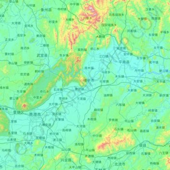
Name: Guigang topographic map, elevation, terrain.
Location: Guigang, Guangxi, China (22.65578 109.20297 24.04395 110.65902)
Average elevation: 185 m
Minimum elevation: 10 m
Maximum elevation: 1,908 m
Other topographic maps
Click on a map to view its topography, its elevation and its terrain.
Yiling Cave
Yiling Cave, 南武大道, Yiling Industrial Concentration Zone, Wuming District, Nanning, Guangxi, China
Average elevation: 140 m
Yangshuo County
Yangshuo County, Guilin, Guangxi, China
Average elevation: 319 m
Pingnan County
China > Guangxi > Guigang > Chini
Pingnan County, Chini, Guigang, Guangxi, China
Average elevation: 36 m