
Napo County topographic map
Interactive map
Click on the map to display elevation.
About this map
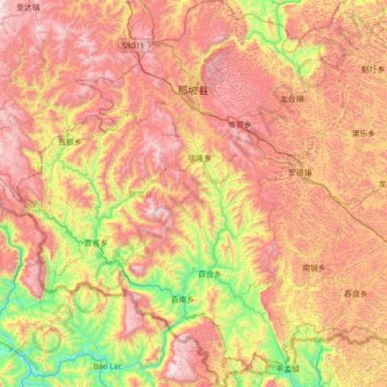
Name: Napo County topographic map, elevation, terrain.
Location: Napo County, Baise City, Guangxi, China (22.91677 105.52397 23.53198 106.10598)
Average elevation: 899 m
Minimum elevation: 154 m
Maximum elevation: 1,658 m
Other topographic maps
Click on a map to view its topography, its elevation and its terrain.
Yiling Cave
Yiling Cave, 南武大道, Yiling Industrial Concentration Zone, Wuming District, Nanning, Guangxi, China
Average elevation: 140 m
Yangshuo County
Yangshuo County, Guilin, Guangxi, China
Average elevation: 319 m
Pingnan County
China > Guangxi > Guigang > Chini
Pingnan County, Chini, Guigang, Guangxi, China
Average elevation: 36 m