
Chihuahua topographic map
Interactive map
Click on the map to display elevation.
About this map
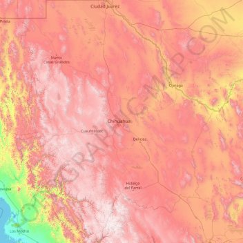
Name: Chihuahua topographic map, elevation, terrain.
Location: Chihuahua, Mexico (25.55866 -109.07498 31.78390 -103.30669)
Average elevation: 1,397 m
Minimum elevation: -1 m
Maximum elevation: 3,119 m
The main mountain range in the state is the Sierra Madre Occidental reaching a maximum altitude of 10,826 ft (3,300 m) known as Cerro Mohinora. Mountains account for one third of the state's surface area which include large coniferous forests. The climate in the mountainous regions varies. Chihuahua has more forests than any other state in Mexico making the area a bountiful source of wood; the mountainous areas are rich in minerals important to Mexico's mining industry. Precipitation and temperature in the mountainous areas depends on the elevation. Between the months of November and March snow storms are possible in the lower elevations and are frequent in the higher elevations. There are several watersheds located in the Sierra Madre Occidental all of the water that flows through the state; most of the rivers finally empty into the Río Grande. Temperatures in some canyons in the state reach over 100 °F (38 °C) in the summer while the same areas rarely drop below 32 °F (0 °C) in the winter. Microclimates found in the heart of the Sierra Madre Occidental in the state could be considered tropical, and wild tropical plants have been found in some canyons. La Barranca del Cobre, or Copper Canyon, a spectacular canyon system larger and deeper than the Grand Canyon; the canyon also contains Mexico's two tallest waterfalls: Basaseachic Falls and Piedra Volada. There are two national parks found in the mountainous area of the state: Cumbres de Majalca National Park and Basaseachic Falls National Park.
Other topographic maps
Click on a map to view its topography, its elevation and its terrain.
Cabo San Lucas
Mexico > Baja California Sur > Los Cabos Municipality
Cabo San Lucas, Los Cabos Municipality, Baja California Sur, 23470, Mexico
Average elevation: 94 m
Papagayo
Mexico > Yucatán > Valladolid
Papagayo, Valladolid, Yucatán, 97783, Mexico
Average elevation: 21 m
Acapulco
Mexico > Guerrero > Acapulco de Juárez
Acapulco, Acapulco de Juárez, Guerrero, 39300, Mexico
Average elevation: 99 m
Sian Ka'an
Mexico > Quintana Roo > Punta Allen
Sian Ka'an, Carretera Tulum - Punta Allen, Punta Allen, Tulum, Quintana Roo, Mexico
Average elevation: 4 m
San Martin Cuautlalpan
Mexico > Mexico > San Martin Cuautlalpan
San Martin Cuautlalpan, Chalco, Mexico, 56643, Mexico
Average elevation: 2,323 m
Los Ángeles
Mexico > Querétaro > Los Ángeles
Los Ángeles, Corregidora, Querétaro, 76927, Mexico
Average elevation: 1,854 m
San Nicolás de los Garza
Mexico > Nuevo León > San Nicolás de los Garza
San Nicolás de los Garza, Nuevo León, 66443, Mexico
Average elevation: 584 m
Mexicali
Mexico > Baja California > Mexicali
Mexicali, Baja California, 21000, Mexico
Average elevation: 18 m
Noria de los Gringos
Mexico > Zacatecas > Noria de los Gringos
Noria de los Gringos, Morelos, Zacatecas, Mexico
Average elevation: 2,205 m
San Felipe Nuevo
Mexico > Yucatán > San Felipe Nuevo
San Felipe Nuevo, Tinum, Yucatán, 97751, Mexico
Average elevation: 27 m
Camino Real
Camino Real, Terrenos del Lote Tancoco, Tancoco, Veracruz, Mexico
Average elevation: 534 m
Arcos Vallarta
Mexico > Jalisco > Guadalajara
Arcos Vallarta, Guadalajara, Jalisco, 44130, Mexico
Average elevation: 1,585 m
Tlaquepaque
Mexico > Jalisco > Tlaquepaque
Tlaquepaque, San Pedro Tlaquepaque, Jalisco, 45590, Mexico
Average elevation: 1,567 m
Piedras Negras
Mexico > Coahuila > Piedras Negras
Piedras Negras, Coahuila, Mexico
Average elevation: 236 m
Sierra Madre Oriental
Sierra Madre Oriental, Galeana, Nuevo León, Mexico
Average elevation: 3,072 m
Rio Grande de Santiago
Rio Grande de Santiago, Juanacatlán, Jalisco, 45620, Mexico
Average elevation: 1,481 m
Pico de Orizaba
Pico de Orizaba, Ciudad Serdán, Puebla, Mexico
Average elevation: 4,967 m
San Pedro Garza García
Mexico > Nuevo León > San Pedro Garza García
San Pedro Garza García, Nuevo León, 66210, Mexico
Average elevation: 798 m
Alberca Colegio Inglés
Alberca Colegio Inglés, Acerina, Colima, 28000, Mexico
Average elevation: 585 m
El Chichón
Mexico > Veracruz > El Chichón
El Chichón, Las Choapas, Veracruz, Mexico
Average elevation: 44 m