
Bukoba topographic map
Interactive map
Click on the map to display elevation.
About this map
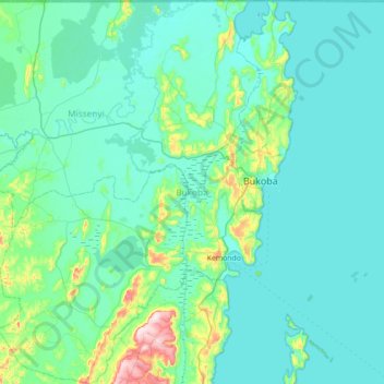
Name: Bukoba topographic map, elevation, terrain.
Location: Bukoba, Kagera, Lake Zone, Tanzanie (-1.70495 31.32963 -0.99902 31.88039)
Average elevation: 1,177 m
Minimum elevation: 1,128 m
Maximum elevation: 1,578 m
Other topographic maps
Click on a map to view its topography, its elevation and its terrain.