
Lara topographic map
Interactive map
Click on the map to display elevation.
About this map
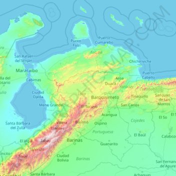
Name: Lara topographic map, elevation, terrain.
Location: Lara, Región Centroccidental, Venezuela (7.62845 -72.41980 12.82845 -67.21980)
Average elevation: 270 m
Minimum elevation: -5 m
Maximum elevation: 4,773 m
Other topographic maps
Click on a map to view its topography, its elevation and its terrain.
Monagas State
The state has many plateaus and savannas located in the southwest. In the northeast and the southeast there are deltaic savannas in which rivers such as the San Juan, Guanipa, Caño Mánamo, and Tigre flow into. In the northwest is a group of mountains belonging to the eastern mountain range. This mountain…
Average elevation: 164 m
Aragua State
Due to its diversity in relief and altitudes that it possesses in all its extension, there are different thermal floors in which the temperature tends to have different climatic characteristics and temperatures that decrease with the increase of the altitude, in the coastal strip dominates a semi-arid and warm…
Average elevation: 472 m
Lara State
Lara's topography consist of high plains and low, broken hills, with a relatively hot and dry climate. Lara depression is located at altitudes between 1,600 and 2,600 ft (487 to 792 m). Among the landscapes of moderate height, the pressures of Carora, Barquisimeto and Yaracuy stand out, while the Sierra de…
Average elevation: 650 m