
Monagas State topographic map
Interactive map
Click on the map to display elevation.
About this map
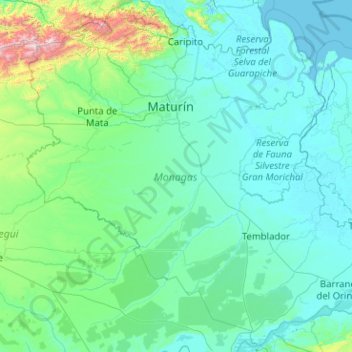
Name: Monagas State topographic map, elevation, terrain.
Location: Monagas State, Venezuela (8.38241 -64.01850 10.30526 -61.99433)
Average elevation: 164 m
Minimum elevation: -1 m
Maximum elevation: 2,480 m
The state has many plateaus and savannas located in the southwest. In the northeast and the southeast there are deltaic savannas in which rivers such as the San Juan, Guanipa, Caño Mánamo, and Tigre flow into. In the northwest is a group of mountains belonging to the eastern mountain range. This mountain range is divided into two massifs: the massif of el Turimiquire (in which the town of San Antonio is located) and the massif of Caripe (in which the town of Caripe is located). Cerro Negro (2000 m.) is the highest mountain of Monagas State. The mountain landscape features geological material from the Cretaceous, constituted exclusively by sedimentary rocks, predominantly sandstone, shale and limestone, with the main geological formations being El Cantil, Barranquín, Guayuta and Querecual; it has elevations between 400 and 2,300 m (1,300 and 7,500 ft) above sea level, with valleys and depressions.
Other topographic maps
Click on a map to view its topography, its elevation and its terrain.
Maturin
Venezuela > Monagas State > Maturin
Maturin, Parroquia San Simón, Municipio Maturín, Monagas State, Región Nororiental, 6201, Venezuela
Average elevation: 56 m
Caracas
Venezuela > Miranda State > Municipio Baruta
Caracas, Parroquia Nuestra Señora del Rosario de Baruta, Municipio Baruta, Miranda State, Venezuela
Average elevation: 735 m
Chama
Venezuela > Mérida > Parroquia Cap. Tabay
Chama, Parroquia Cap. Tabay, Municipio Santos Marquina, Mérida, 516, Venezuela
Average elevation: 2,213 m
Parroquia Raul Leoni
Venezuela > Vargas > Parroquia Raul Leoni
Parroquia Raul Leoni, Municipio Vargas, Vargas, Región Capital, 1162, Venezuela
Average elevation: 305 m
Calabozo
Venezuela > Guarico State > Calabozo
Calabozo, Distrito Miranda, Guarico State, 2312, Venezuela
Average elevation: 92 m
San Fernando de Apure
Venezuela > Apure State > San Fernando de Apure
San Fernando de Apure, Municipio San Fernando, Apure State, 7001, Venezuela
Average elevation: 45 m
Parroquia El Recreo
Venezuela > Capital District > Parroquia El Recreo
Parroquia El Recreo, Municipio Libertador, Capital District, Región Capital, Venezuela
Average elevation: 1,269 m
Urbanización: Montalbán I
Venezuela > Capital District > Urbanización: Montalbán I
Urbanización: Montalbán I, Municipio Libertador, Capital District, Región Capital, Venezuela
Average elevation: 959 m
Isla Margarita
Isla Margarita, Municipio Díaz, Nueva Esparta, Venezuela
Average elevation: 12 m
Río Orinoco
Venezuela > Delta Amacuro State
Río Orinoco, Parroquia Juan Bautista Arismendi, Delta Amacuro State, Venezuela
Average elevation: 114 m
Municipio Santos Marquina
Municipio Santos Marquina, Mérida, Venezuela
Average elevation: 2,910 m
La Corona Glacier
La Corona Glacier, Mérida, Municipio Libertador, Mérida, Venezuela
Average elevation: 4,387 m
Cerro Las Nieves
Venezuela > Carabobo > Puerto Cabello
Cerro Las Nieves, Puerto Cabello, Municipio Puerto Cabello, Carabobo, Venezuela
Average elevation: 226 m
Lake Maracaibo
Lake Maracaibo, Tía Juana, Municipio Simón Bolívar, Zulia, 4036, Venezuela
Average elevation: 148 m
San Cristóbal
Venezuela > Táchira > San Cristóbal
San Cristóbal, Municipio San Cristóbal, Táchira, 5001, Venezuela
Average elevation: 1,220 m
Bourgoin (North) Glacier
Bourgoin (North) Glacier, Mérida, Municipio Libertador, Mérida, Venezuela
Average elevation: 4,395 m
Caracas
Venezuela > Capital District > Caracas
Caracas, Municipio Libertador, Capital District, Región Capital, 1010-A, Venezuela
Average elevation: 858 m
Tucupita
Venezuela > Delta Amacuro State > Tucupita
Tucupita, Parroquia Monseñor Argimiro García, Delta Amacuro State, 6401, Venezuela
Average elevation: 5 m