
Lake Kivu topographic map
Interactive map
Click on the map to display elevation.
About this map
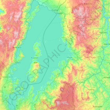
Name: Lake Kivu topographic map, elevation, terrain.
Location: Lake Kivu, Rwanda (-2.50058 28.83485 -1.58360 29.38199)
Average elevation: 1,857 m
Minimum elevation: 1,402 m
Maximum elevation: 3,015 m
Other topographic maps
Click on a map to view its topography, its elevation and its terrain.
Nyarugenge District
Nyarugenge District, Kigali City, Rwanda
Average elevation: 1,486 m
Ngoma
Rwanda > Southern Province > Ngoma
Ngoma, Nyaruguru District, Southern Province, Rwanda
Average elevation: 1,637 m
Kigoma
Rwanda > Southern Province > Kigoma
Kigoma, Huye, Southern Province, Rwanda
Average elevation: 1,719 m
Mount Karisimbi
Rwanda > Northern Province > Gataraga
Mount Karisimbi, Gataraga, Musanze, Northern Province, Rwanda
Average elevation: 3,924 m