Geolocate

Chambeshi River topographic map

Interactive map

Click on the map to display elevation.

About this map

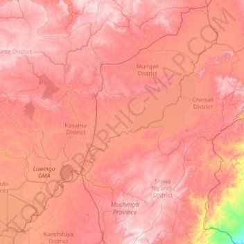
Name: Chambeshi River topographic map, elevation, terrain.

Location: Chambeshi River, Northern Province, Zambia (-11.59830 30.28863 -9.34254 32.14427)

Average elevation: 1,298 m

Minimum elevation: 634 m

Maximum elevation: 1,825 m

Other topographic maps

Click on a map to view its topography, its elevation and its terrain.

Kasama District

Zambia > Northern Province

Average elevation: 1,299 m

Chilubi Island

Zambia > Northern Province

Average elevation: 1,169 m

Kasama

Zambia > Northern Province > Kasama

Average elevation: 1,363 m

Mungwi

Zambia > Northern Province > Mungwi

Average elevation: 1,376 m

Isangano National Park

Zambia > Northern Province

Average elevation: 1,184 m

Lake Mweru Wantipa

Zambia > Northern Province

Average elevation: 1,044 m