
Machakos County topographic map
Interactive map
Click on the map to display elevation.
About this map
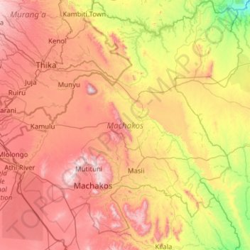
Name: Machakos County topographic map, elevation, terrain.
Location: Machakos County, Eastern, Kenya (-1.78016 36.87891 -0.77705 37.86750)
Average elevation: 1,347 m
Minimum elevation: 721 m
Maximum elevation: 2,138 m
The local climate is semi-arid with hilly terrain and an altitude of 1000 to 2100 metres above sea level.
Other topographic maps
Click on a map to view its topography, its elevation and its terrain.
Siakago
Kenya > Embu County > Siakago
Siakago, Embu County, East Kenya, Kenya
Average elevation: 1,201 m
Nyeri
Kenya > Nyeri > Nyeri Central
Nyeri, Nyeri Central, Nyeri, Central Kenya, Kenya
Average elevation: 1,796 m