
Kajiado County topographic map
Interactive map
Click on the map to display elevation.
About this map
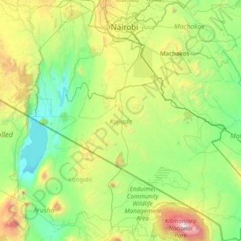
Name: Kajiado County topographic map, elevation, terrain.
Location: Kajiado County, Rift Valley, Kenya (-3.19615 36.00074 -1.04677 37.93793)
Average elevation: 1,408 m
Minimum elevation: 594 m
Maximum elevation: 5,828 m
Other topographic maps
Click on a map to view its topography, its elevation and its terrain.
Siakago
Kenya > Embu County > Siakago
Siakago, Embu County, East Kenya, Kenya
Average elevation: 1,201 m
Nyeri
Kenya > Nyeri > Nyeri Central
Nyeri, Nyeri Central, Nyeri, Central Kenya, Kenya
Average elevation: 1,796 m