
Tanganyika topographic map
Interactive map
Click on the map to display elevation.
About this map
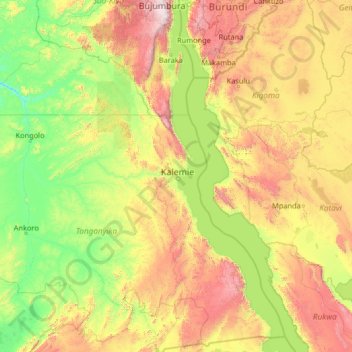
Name: Tanganyika topographic map, elevation, terrain.
Location: Tanganyika, Democratic Republic of the Congo (-8.46100 26.61786 -3.34100 31.73786)
Average elevation: 1,038 m
Minimum elevation: 475 m
Maximum elevation: 3,215 m
Other topographic maps
Click on a map to view its topography, its elevation and its terrain.
Mambwe
Democratic Republic of the Congo > Tanganyika
Mambwe, Tanganyika, Democratic Republic of the Congo
Average elevation: 769 m
Nsenga
Democratic Republic of the Congo > Tanganyika > Nsenga
Nsenga, Tanganyika, Democratic Republic of the Congo
Average elevation: 1,601 m