
Federal Territory of Kuala Lumpur topographic map
Interactive map
Click on the map to display elevation.
Federal Territory of Kuala Lumpur
Located in the centre of Selangor state, Kuala Lumpur was a territory of Selangor State Government. In 1974, Kuala Lumpur was separated from Selangor to form the first Federal Territory governed directly by the Malaysian Federal Government. Its location within the most developed state on the west coast of Peninsular Malaysia, which has wider flat land than the east coast, has contributed to its faster development relative to other cities in Malaysia. The municipality of the city covers an area of 243 km2 (94 sq mi), with an average elevation of 81.95 m (268.9 ft).
About this map
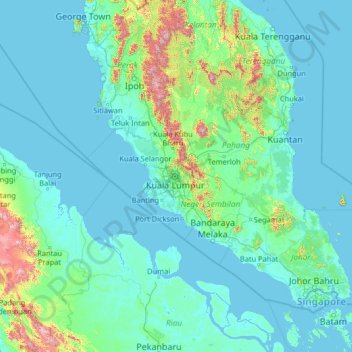
Name: Federal Territory of Kuala Lumpur topographic map, elevation, terrain.
Location: Federal Territory of Kuala Lumpur, Malaysia (0.55266 99.10222 5.75266 104.30222)
Average elevation: 119 m
Minimum elevation: -3 m
Maximum elevation: 2,169 m
Other topographic maps
Click on a map to view its topography, its elevation and its terrain.
George Town
The jurisdiction of George Town covers an area of approximately 306 km2 (118 sq mi), encompassing the entirety of Penang Island and nine surrounding islets. George Town is slightly more than two-fifths the size of Singapore. The 295 km2 (114 sq mi) Penang Island has an uneven terrain with a mountainous…
Average elevation: 52 m
Sabah
The jungles of Sabah host a diverse array of plant and animal species. Most of Sabah's biodiversity is located in the forest reserve areas, which formed half of its total landmass of 7.34 million hectares. Its forest reserve are part of the 20 million hectares equatorial rainforests demarcated under the "Heart…
Average elevation: 115 m