
Thank you for supporting this site ❤️
Make a donation
Make a donation
Kuantan topographic map
Click on the map to display elevation.
Thank you for supporting this site ❤️
Make a donation
Make a donation
About this map
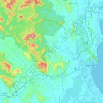
Name: Kuantan topographic map, elevation, terrain.
Location: Kuantan, Pahang, Malaysia (3.59841 102.70794 4.19419 103.44666)
Average elevation: 147 m
Minimum elevation: -1 m
Maximum elevation: 1,446 m
Thank you for supporting this site ❤️
Make a donation
Make a donation