
Make a donation
Kastella topographic map
Click on the map to display elevation.
Make a donation
About this map
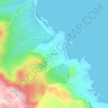
Name: Kastella topographic map, elevation, terrain.
Average elevation: 117 m
Minimum elevation: -1 m
Maximum elevation: 514 m
Make a donation
Other topographic maps
Click on a map to view its topography, its elevation and its terrain.
Municipal Unit of Sparta
Greece > Peloponnese, Western Greece and the Ionian > Laconia Regional Unit
Average elevation: 450 m
Municipality of Monemvasia
Greece > Peloponnese, Western Greece and the Ionian > Laconia Regional Unit
Average elevation: 131 m
East Mani Municipal Unit
Greece > Peloponnese, Western Greece and the Ionian > Laconia Regional Unit
Average elevation: 93 m
Municipal Unit of Sparta
Greece > Peloponnese, Western Greece and the Ionian > Laconia Regional Unit
Average elevation: 450 m
Make a donation
Sparta
Greece > Peloponnese, Western Greece and the Ionian > Laconia Regional Unit
Average elevation: 199 m
Municipal Unit of Sparta
Greece > Peloponnese, Western Greece and the Ionian > Laconia Regional Unit
Average elevation: 450 m
Municipal Unit of Sparta
Greece > Peloponnese, Western Greece and the Ionian > Laconia Regional Unit
Average elevation: 450 m
Sparta
Greece > Peloponnese, Western Greece and the Ionian > Laconia Regional Unit > Municipality of Sparta > Χαρίσιο
In 1907, the location of the sanctuary of Athena "of the Brazen House" (Χαλκίοικος, Chalkioikos) was determined to be on the acropolis immediately above the theatre. Though the actual temple is almost completely destroyed, the site has produced the longest extant archaic inscription in Laconia,…
Average elevation: 214 m
Make a donation
Spartia
Greece > Peloponnese, Western Greece and the Ionian > Laconia Regional Unit
Average elevation: 833 m
Laconia Regional Unit
Greece > Peloponnese, Western Greece and the Ionian > Laconia Regional Unit
Average elevation: 199 m
Municipality of Sparta
Greece > Peloponnese, Western Greece and the Ionian > Laconia Regional Unit
Average elevation: 699 m