
Fountain Hill topographic map
Interactive map
Click on the map to display elevation.
About this map
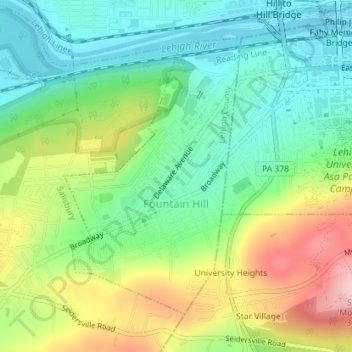
Name: Fountain Hill topographic map, elevation, terrain.
Location: Fountain Hill, Lehigh County, Pennsylvania, United States (40.59302 -75.40648 40.61422 -75.38859)
Average elevation: 147 m
Minimum elevation: 63 m
Maximum elevation: 297 m
Other topographic maps
Click on a map to view its topography, its elevation and its terrain.
East Texas
United States > Pennsylvania > Lehigh County > Lower Macungie Township
East Texas, Lower Macungie Township, Lehigh County, Pennsylvania, 18046, United States
Average elevation: 126 m
East Allentown
United States > Pennsylvania > Lehigh County > Allentown
East Allentown, Allentown, Lehigh County, Pennsylvania, United States
Average elevation: 113 m
Upper Milford Township
United States > Pennsylvania > Lehigh County
Upper Milford Township, Lehigh County, Pennsylvania, United States
Average elevation: 192 m
Lynn Township
United States > Pennsylvania > Lehigh County
Lynn Township, Lehigh County, Pennsylvania, 18066, United States
Average elevation: 221 m
Fogelsville
United States > Pennsylvania > Lehigh County > Upper Macungie Township
Fogelsville, Upper Macungie Township, Lehigh County, Pennsylvania, 18195, United States
Average elevation: 155 m
South Whitehall Township
United States > Pennsylvania > Lehigh County
South Whitehall Township, Lehigh County, Pennsylvania, 18069, United States
Average elevation: 133 m
Fullerton
United States > Pennsylvania > Lehigh County > Whitehall > Fullerton
Fullerton, Whitehall, Lehigh County, Pennsylvania, United States
Average elevation: 106 m
Egypt
United States > Pennsylvania > Lehigh County > Whitehall
Egypt, Whitehall, Lehigh County, Pennsylvania, 18037, United States
Average elevation: 136 m
Hensingersville
United States > Pennsylvania > Lehigh County > Lower Macungie Township
Hensingersville, Lower Macungie Township, Lehigh County, Pennsylvania, 18011, United States
Average elevation: 203 m
North Whitehall Township
United States > Pennsylvania > Lehigh County
North Whitehall Township, Lehigh County, Pennsylvania, United States
Average elevation: 171 m
Bake Oven Knob
United States > Pennsylvania > Lehigh County > Heidelberg Township
Bake Oven Knob, Heidelberg Township, Lehigh County, Pennsylvania, 18212, United States
Average elevation: 310 m
Emmaus
United States > Pennsylvania > Lehigh County
Emmaus, Lehigh County, Pennsylvania, 18049, United States
Average elevation: 154 m
Coplay
United States > Pennsylvania > Lehigh County
Coplay, Lehigh County, Pennsylvania, United States
Average elevation: 107 m
Neffs
United States > Pennsylvania > Lehigh County > North Whitehall Township
Neffs, North Whitehall Township, Lehigh County, Pennsylvania, 18065, United States
Average elevation: 208 m
Newside
United States > Pennsylvania > Lehigh County > Washington Township
Newside, Washington Township, Lehigh County, Pennsylvania, 18065, United States
Average elevation: 206 m
Laurys Station
United States > Pennsylvania > Lehigh County > North Whitehall Township
Laurys Station, North Whitehall Township, Lehigh County, Pennsylvania, 18059, United States
Average elevation: 152 m
Lower Milford
United States > Pennsylvania > Lehigh County
Lower Milford, Lehigh County, Pennsylvania, 18060, United States
Average elevation: 193 m
Allentown
United States > Pennsylvania > Lehigh County
Allentown, Lehigh County, Pennsylvania, United States
Average elevation: 129 m
Lower Macungie Township
United States > Pennsylvania > Lehigh County
Lower Macungie Township, Lehigh County, Pennsylvania, United States
Average elevation: 157 m
Milford Park
United States > Pennsylvania > Lehigh County > Upper Milford Township
Milford Park, Upper Milford Township, Lehigh County, Pennsylvania, 18092, United States
Average elevation: 221 m
Upper Saucon
United States > Pennsylvania > Lehigh County > Upper Saucon
Upper Saucon, Lehigh County, Pennsylvania, United States
Average elevation: 175 m
Salisbury
United States > Pennsylvania > Lehigh County
Salisbury, Lehigh County, Pennsylvania, United States
Average elevation: 143 m
Old Zionsville
United States > Pennsylvania > Lehigh County > Upper Milford Township
Old Zionsville, Upper Milford Township, Lehigh County, Pennsylvania, 18068, United States
Average elevation: 217 m
Alburtis
United States > Pennsylvania > Lehigh County > Alburtis
Alburtis, Lehigh County, Pennsylvania, United States
Average elevation: 145 m
Center Valley
United States > Pennsylvania > Lehigh County > Upper Saucon
Center Valley, Upper Saucon, Lehigh County, Pennsylvania, 18034, United States
Average elevation: 152 m
Wescosville
United States > Pennsylvania > Lehigh County > Lower Macungie Township
Wescosville, Lower Macungie Township, Lehigh County, Pennsylvania, 18106, United States
Average elevation: 128 m
Whitehall
United States > Pennsylvania > Lehigh County
Whitehall, Lehigh County, Pennsylvania, United States
Average elevation: 122 m
Weisenberg Township
United States > Pennsylvania > Lehigh County > Weisenberg Township
Weisenberg Township, Lehigh County, Pennsylvania, 18051, United States
Average elevation: 203 m
Schnecksville
United States > Pennsylvania > Lehigh County > North Whitehall Township
Schnecksville, North Whitehall Township, Lehigh County, Pennsylvania, 18078, United States
Average elevation: 197 m
New Tripoli
United States > Pennsylvania > Lehigh County > Lynn Township
New Tripoli, Lynn Township, Lehigh County, Pennsylvania, 18066, United States
Average elevation: 205 m
Metamora Station
United States > Pennsylvania > Lehigh County > South Whitehall Township > Metamora Station
Metamora Station, South Whitehall Township, Lehigh County, Pennsylvania, 18104, United States
Average elevation: 125 m
Crackersport
United States > Pennsylvania > Lehigh County > South Whitehall Township
Crackersport, South Whitehall Township, Lehigh County, Pennsylvania, 18104, United States
Average elevation: 138 m
Slatington
United States > Pennsylvania > Lehigh County
Slatington, Lehigh County, Pennsylvania, United States
Average elevation: 153 m
Hanover Township
United States > Pennsylvania > Lehigh County > Hanover Township
Hanover Township, Lehigh County, Pennsylvania, United States
Average elevation: 110 m
Coopersburg
United States > Pennsylvania > Lehigh County
Coopersburg, Lehigh County, Pennsylvania, United States
Average elevation: 167 m
Upper Macungie Township
United States > Pennsylvania > Lehigh County
Upper Macungie Township, Lehigh County, Pennsylvania, United States
Average elevation: 153 m
Macungie
United States > Pennsylvania > Lehigh County
Macungie, Lehigh County, Pennsylvania, United States
Average elevation: 133 m