
Rulhe topographic map
Interactive map
Click on the map to display elevation.
About this map
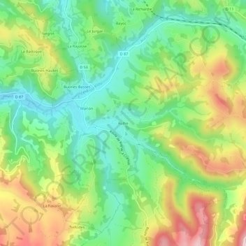
Name: Rulhe topographic map, elevation, terrain.
Average elevation: 416 m
Minimum elevation: 299 m
Maximum elevation: 596 m
Other topographic maps
Click on a map to view its topography, its elevation and its terrain.
La Pradalie
France > Occitanie > Aveyron > Auzits
La Pradalie, Auzits, Villefranche-de-Rouergue, Aveyron, Occitanie, France métropolitaine, 12390, France
Average elevation: 335 m
Le Plateau d'Hymes
France > Occitanie > Aveyron > Auzits
Le Plateau d'Hymes, Auzits, Villefranche-de-Rouergue, Aveyron, Occitanie, France métropolitaine, 12390, France
Average elevation: 341 m