
Needham topographic map
Interactive map
Click on the map to display elevation.
About this map
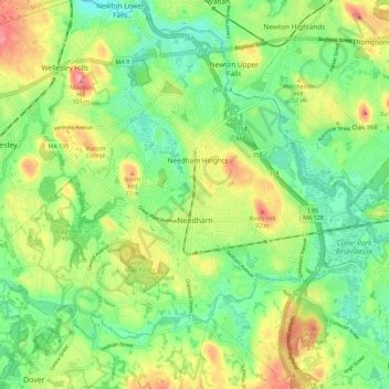
Name: Needham topographic map, elevation, terrain.
Location: Needham, Norfolk County, Massachusetts, United States (42.25484 -71.30127 42.31652 -71.18820)
Average elevation: 46 m
Minimum elevation: 11 m
Maximum elevation: 98 m
Needham's area is roughly in the shape of an acute, northward-pointing triangle. The Charles River forms nearly all of the southern and northeastern boundaries, the town line with Wellesley forming the third, northwestern one. In addition to Wellesley on the northwest, Needham borders Newton and the West Roxbury section of Boston on the northeast, and Dover, Westwood, and Dedham on the south. The majority of Cutler Park is in Needham and is located along the Charles River and the border with Newton and West Roxbury. Elevations in Needham range from 85 feet above sea level at Rosemary Meadows to 180 feet at Needham Square and 300 feet at Bird's Hill.
Other topographic maps
Click on a map to view its topography, its elevation and its terrain.
Brookline
United States > Massachusetts > Norfolk County
Brookline, Norfolk County, Massachusetts, United States
Average elevation: 35 m
Summer Heights
United States > Massachusetts > Norfolk County > Canton
Summer Heights, Canton, Norfolk County, Massachusetts, 02021, United States
Average elevation: 31 m
Wellesley
United States > Massachusetts > Norfolk County
Wellesley, Norfolk County, Massachusetts, United States
Average elevation: 52 m
Needham Junction
United States > Massachusetts > Norfolk County > Needham
Needham Junction, Needham, Norfolk County, Massachusetts, 02492, United States
Average elevation: 46 m
Franklin
United States > Massachusetts > Norfolk County
Franklin, Norfolk County, Massachusetts, 02038, United States
Average elevation: 80 m
Bellingham
United States > Massachusetts > Norfolk County
Bellingham, Norfolk County, Massachusetts, 02019, United States
Average elevation: 84 m
Westwood
United States > Massachusetts > Norfolk County
Westwood, Norfolk County, Massachusetts, 02090, United States
Average elevation: 58 m
Cedar
United States > Massachusetts > Norfolk County > Walpole
Cedar, Walpole, Norfolk County, Massachusetts, 02081, United States
Average elevation: 66 m
North Foxboro
United States > Massachusetts > Norfolk County > Foxborough
North Foxboro, Foxborough, Norfolk County, Massachusetts, 02035, United States
Average elevation: 90 m
Lake Massapoag
United States > Massachusetts > Norfolk County > Sharon
Lake Massapoag, Sharon, Norfolk County, Massachusetts, United States
Average elevation: 84 m
Lake Archer
United States > Massachusetts > Norfolk County > Wrentham
Lake Archer, Wrentham, Norfolk County, Massachusetts, United States
Average elevation: 72 m
Clark Pond Reservoir
United States > Massachusetts > Norfolk County > Walpole
Clark Pond Reservoir, Carpenter Road, Walpole, Norfolk County, Massachusetts, 02081, United States
Average elevation: 65 m
Foxborough
United States > Massachusetts > Norfolk County
Foxborough, Norfolk County, Massachusetts, 02035, United States
Average elevation: 70 m
Weymouth
United States > Massachusetts > Norfolk County
Weymouth, Norfolk County, Massachusetts, United States
Average elevation: 28 m
Quincy Bay
United States > Massachusetts > Norfolk County > Quincy
Quincy Bay, Quincy, Norfolk County, Massachusetts, 02170, United States
Average elevation: 0 m
Walpole
United States > Massachusetts > Norfolk County
Walpole, Norfolk County, Massachusetts, United States
Average elevation: 62 m
Plainville
United States > Massachusetts > Norfolk County
Plainville, Norfolk County, Massachusetts, 02762, United States
Average elevation: 79 m
Four Corners
United States > Massachusetts > Norfolk County > Stoughton
Four Corners, Stoughton, Norfolk County, Massachusetts, 03072, United States
Average elevation: 65 m
Forbes Wharf
United States > Massachusetts > Norfolk County > Milton
Forbes Wharf, Milton, Norfolk County, Massachusetts, 02124, United States
Average elevation: 19 m
Quincy Point
United States > Massachusetts > Norfolk County > Quincy
Quincy Point, Quincy, Norfolk County, Massachusetts, 02169, United States
Average elevation: 12 m
Saint Marks Park
United States > Massachusetts > Norfolk County > Brookline
Saint Marks Park, Coolidge Corner, Brookline, Norfolk County, Massachusetts, 02446, United States
Average elevation: 25 m
Stoughton
United States > Massachusetts > Norfolk County
Stoughton, Norfolk County, Massachusetts, United States
Average elevation: 66 m
Sharon
United States > Massachusetts > Norfolk County
Sharon, Norfolk County, Massachusetts, 02067, United States
Average elevation: 71 m
Sabrina Lake
United States > Massachusetts > Norfolk County > Needham
Sabrina Lake, Needham, Norfolk County, Massachusetts, United States
Average elevation: 45 m
Canton
United States > Massachusetts > Norfolk County
Canton, Norfolk County, Massachusetts, 02021, United States
Average elevation: 44 m
Crownridge Estates
United States > Massachusetts > Norfolk County > Medfield
Crownridge Estates, Medfield, Norfolk County, Massachusetts, 02052, United States
Average elevation: 47 m
Single Tree Hill
United States > Massachusetts > Norfolk County > Brookline
Single Tree Hill, Brookline, Norfolk County, Massachusetts, 02445-5841, United States
Average elevation: 58 m
Wrentham
United States > Massachusetts > Norfolk County > Wrentham > Wrentham
Wrentham, Norfolk County, Massachusetts, 02093, United States
Average elevation: 79 m
Wellesley Farms
United States > Massachusetts > Norfolk County > Wellesley > Wellesley Farms
Wellesley Farms, Wellesley, Norfolk County, Massachusetts, 02481-3120, United States
Average elevation: 48 m
Ashcroft
United States > Massachusetts > Norfolk County > Dedham > Ashcroft
Ashcroft, Dedham, Norfolk County, Massachusetts, 02026-5036, United States
Average elevation: 30 m
Medfield
United States > Massachusetts > Norfolk County
Medfield, Norfolk County, Massachusetts, 02052, United States
Average elevation: 57 m
Braintree
United States > Massachusetts > Norfolk County
Braintree, Norfolk County, Massachusetts, 02184, United States
Average elevation: 39 m
Quincy
United States > Massachusetts > Norfolk County
Quincy, Norfolk County, Massachusetts, United States
Average elevation: 19 m
Milton
United States > Massachusetts > Norfolk County
Milton, Norfolk County, Massachusetts, United States
Average elevation: 41 m