
Thank you for supporting this site ❤️
Make a donation
Make a donation
Moosinning topographic map
Click on the map to display elevation.
Thank you for supporting this site ❤️
Make a donation
Make a donation
About this map
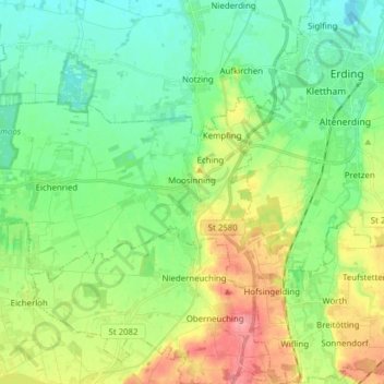
Name: Moosinning topographic map, elevation, terrain.
Location: Moosinning, Landkreis Erding, Bayern, 85452, Deutschland (48.24879 11.73117 48.30037 11.88582)
Average elevation: 479 m
Minimum elevation: 450 m
Maximum elevation: 535 m
Thank you for supporting this site ❤️
Make a donation
Make a donation
Other topographic maps
Click on a map to view its topography, its elevation and its terrain.