
Francorchamps topographic map
Interactive map
Click on the map to display elevation.
About this map
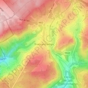
Name: Francorchamps topographic map, elevation, terrain.
Average elevation: 482 m
Minimum elevation: 356 m
Maximum elevation: 575 m
Other topographic maps
Click on a map to view its topography, its elevation and its terrain.
Renardmont
Belgique > Liège > Verviers > Stavelot
Renardmont, Stavelot, Verviers, Liège, Wallonie, 4970, Belgique
Average elevation: 390 m
La Vaulx Richard
Belgique > Liège > Verviers > Stavelot
La Vaulx Richard, Stavelot, Verviers, Liège, Wallonie, 4970, Belgique
Average elevation: 397 m
Cascade de Coo
Belgique > Liège > Verviers > Stavelot
Cascade de Coo, Stavelot, Verviers, Liège, Wallonie, 4970, Belgique
Average elevation: 335 m
Parfondruy
Belgique > Liège > Verviers > Stavelot > Parfondruy
Parfondruy, Stavelot, Verviers, Liège, Wallonie, 4970, Belgique
Average elevation: 388 m