
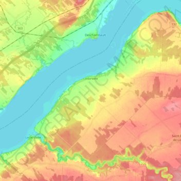
Lotbinière topographic map
Interactive map
Click on the map to display elevation.
About this map
Name: Lotbinière topographic map, elevation, terrain.
Average elevation: 38 m
Minimum elevation: 0 m
Maximum elevation: 82 m
Other topographic maps
Click on a map to view its topography, its elevation and its terrain.
Saint-Édouard-de-Lotbinière
Canada > Quebec > Lotbinière (MRC)
Saint-Édouard-de-Lotbinière, Lotbinière (MRC), Chaudière-Appalaches, Quebec, G0S 1Y0, Canada
Average elevation: 75 m
Saint-Agapit
Canada > Quebec > Lotbinière (MRC) > Saint-Agapit
Saint-Agapit, Lotbinière (MRC), Chaudiere-Appalaches, Quebec, G0S 1Z0, Canada
Average elevation: 130 m
Saint-Narcisse-de-Beaurivage
Canada > Quebec > Lotbinière (MRC) > Saint-Narcisse-de-Beaurivage
Saint-Narcisse-de-Beaurivage, Lotbinière (MRC), Chaudiere-Appalaches, Quebec, G0S 1W0, Canada
Average elevation: 156 m