
Dallas topographic map
Interactive map
Click on the map to display elevation.
About this map
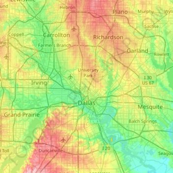
Name: Dallas topographic map, elevation, terrain.
Location: Dallas, Dallas County, Texas, États-Unis d'Amérique (32.61322 -97.00048 33.02394 -96.46363)
Average elevation: 160 m
Minimum elevation: 108 m
Maximum elevation: 259 m
Other topographic maps
Click on a map to view its topography, its elevation and its terrain.
Addison
États-Unis d'Amérique > Texas > Dallas County > Addison
Addison, Dallas County, Texas, États-Unis d'Amérique
Average elevation: 187 m
Garland
États-Unis d'Amérique > Texas > Dallas County
Garland, Dallas County, Texas, États-Unis d'Amérique
Average elevation: 165 m