
Dhaka Division topographic map
Interactive map
Click on the map to display elevation.
About this map
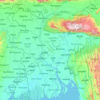
Name: Dhaka Division topographic map, elevation, terrain.
Location: Dhaka Division, Bangladesh (21.71118 87.65618 26.83118 92.77618)
Average elevation: 115 m
Minimum elevation: -3 m
Maximum elevation: 1,922 m
Other topographic maps
Click on a map to view its topography, its elevation and its terrain.
Dhamrai
Bangladesh > Dhaka Division > Dhamrai
Dhamrai, Dhamrai Subdistrict, Dhaka District, Dhaka Division, 1350, Bangladesh
Average elevation: 9 m
Narayanganj
Bangladesh > Dhaka Division > Narayanganj
Narayanganj, Dhaka Division, 1400, Bangladesh
Average elevation: 6 m