
Otur topographic map
Interactive map
Click on the map to display elevation.
About this map
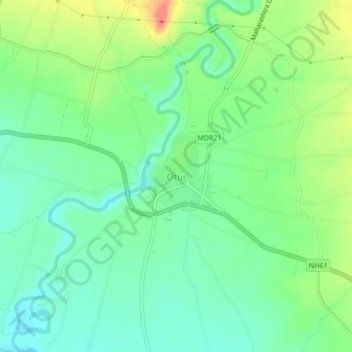
Name: Otur topographic map, elevation, terrain.
Location: Otur, Junnar, Maharashtra, 412409, India (19.24336 73.96054 19.28336 74.00054)
Average elevation: 673 m
Minimum elevation: 652 m
Maximum elevation: 712 m
Other topographic maps
Click on a map to view its topography, its elevation and its terrain.
Shivneri Fort
India > Maharashtra > Junnar > Junnar
Shivneri Fort, Junnar, Pune, Maharashtra, India
Average elevation: 746 m
Ghatghar
India > Maharashtra > Junnar
Ghatghar, Junnar, Pune, Maharashtra, India
Average elevation: 757 m
Naneghat
India > Maharashtra > Junnar
Naneghat, Junnar, Pune, Maharashtra, India
Average elevation: 422 m
Yedgaon Reservoir
India > Maharashtra > Junnar
Yedgaon Reservoir, Junnar, Pune District, Maharashtra, India
Average elevation: 650 m