
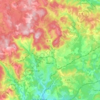
Meymac topographic map
Interactive map
Click on the map to display elevation.
About this map
Name: Meymac topographic map, elevation, terrain.
Average elevation: 763 m
Minimum elevation: 584 m
Maximum elevation: 981 m
Other topographic maps
Click on a map to view its topography, its elevation and its terrain.
Plos
France > Nouvelle-Aquitaine > Corrèze > Forgès
Plos, Forgès, Tulle, Corrèze, Nouvelle-Aquitaine, Metropolitan France, 19380, France
Average elevation: 361 m
Sarran
France > Nouvelle-Aquitaine > Corrèze
Sarran, Ussel, Corrèze, Nouvelle-Aquitaine, Metropolitan France, 19800, France
Average elevation: 622 m
Seilhac
France > Nouvelle-Aquitaine > Corrèze
Seilhac, Tulle, Corrèze, Nouvelle-Aquitaine, Metropolitan France, 19700, France
Average elevation: 459 m
Chabrignac
France > Nouvelle-Aquitaine > Corrèze
Chabrignac, Brive-la-Gaillarde, Corrèze, Nouvelle-Aquitaine, Metropolitan France, 19350, France
Average elevation: 240 m
Servières-le-Château
France > Nouvelle-Aquitaine > Corrèze
Servières-le-Château, Tulle, Corrèze, Nouvelle-Aquitaine, Metropolitan France, 19220, France
Average elevation: 485 m
Millevaches
France > Nouvelle-Aquitaine > Corrèze
Millevaches, Ussel, Corrèze, Nouvelle-Aquitaine, Metropolitan France, 19290, France
Average elevation: 888 m
Curemonte
France > Nouvelle-Aquitaine > Corrèze
Curemonte, Brive-la-Gaillarde, Corrèze, Nouvelle-Aquitaine, Metropolitan France, 19500, France
Average elevation: 186 m
Toy-Viam
France > Nouvelle-Aquitaine > Corrèze
Toy-Viam, Tulle, Corrèze, Nouvelle-Aquitaine, Metropolitan France, 19170, France
Average elevation: 737 m
Le Bois de Phili
France > Nouvelle-Aquitaine > Corrèze > Uzerche
Le Bois de Phili, Uzerche, Tulle, Corrèze, Nouvelle-Aquitaine, Metropolitan France, 19140, France
Average elevation: 376 m
La Nadalie
France > Nouvelle-Aquitaine > Corrèze > Saint-Pantaléon-de-Larche
La Nadalie, Saint-Pantaléon-de-Larche, Brive-la-Gaillarde, Corrèze, Nouvelle-Aquitaine, Metropolitan France, 19600, France
Average elevation: 147 m
Le Mons
France > Nouvelle-Aquitaine > Corrèze > Sainte-Féréole
Le Mons, Sainte-Féréole, Brive-la-Gaillarde, Corrèze, Nouvelle-Aquitaine, Metropolitan France, 19270, France
Average elevation: 341 m
Objat
France > Nouvelle-Aquitaine > Corrèze
Objat, Brive-la-Gaillarde, Corrèze, Nouvelle-Aquitaine, Metropolitan France, 19130, France
Average elevation: 155 m
Saint-Sornin-Lavolps
France > Nouvelle-Aquitaine > Corrèze
Saint-Sornin-Lavolps, Brive-la-Gaillarde, Corrèze, Nouvelle-Aquitaine, Metropolitan France, 19230, France
Average elevation: 390 m
Yssandon
France > Nouvelle-Aquitaine > Corrèze
Yssandon, Brive-la-Gaillarde, Corrèze, Nouvelle-Aquitaine, Metropolitan France, 19310, France
Average elevation: 182 m
Beynat
France > Nouvelle-Aquitaine > Corrèze
Beynat, Brive-la-Gaillarde, Corrèze, Nouvelle-Aquitaine, Metropolitan France, 19190, France
Average elevation: 419 m
Pierrefitte
France > Nouvelle-Aquitaine > Corrèze
Pierrefitte, Tulle, Corrèze, Nouvelle-Aquitaine, Metropolitan France, 19450, France
Average elevation: 388 m
Meyssac
France > Nouvelle-Aquitaine > Corrèze
Meyssac, Brive-la-Gaillarde, Corrèze, Nouvelle-Aquitaine, Metropolitan France, 19500, France
Average elevation: 223 m
Esparcillac
France > Nouvelle-Aquitaine > Corrèze > Saint-Martin-Sepert
Esparcillac, Saint-Martin-Sepert, Brive-la-Gaillarde, Corrèze, Nouvelle-Aquitaine, Metropolitan France, 19210, France
Average elevation: 419 m
Escuroux
France > Nouvelle-Aquitaine > Corrèze > Varetz
Escuroux, Varetz, Brive-la-Gaillarde, Corrèze, Nouvelle-Aquitaine, Metropolitan France, 19240, France
Average elevation: 174 m
Perpezac-le-Noir
France > Nouvelle-Aquitaine > Corrèze
Perpezac-le-Noir, Tulle, Corrèze, Nouvelle-Aquitaine, Metropolitan France, 19410, France
Average elevation: 367 m
Sexcles
France > Nouvelle-Aquitaine > Corrèze > Sexcles
Sexcles, Tulle, Corrèze, Nouvelle-Aquitaine, Metropolitan France, 19430, France
Average elevation: 476 m
Merlines
France > Nouvelle-Aquitaine > Corrèze > Merlines
Merlines, Ussel, Corrèze, Nouvelle-Aquitaine, Metropolitan France, 19340, France
Average elevation: 720 m
Larche
France > Nouvelle-Aquitaine > Corrèze
Larche, Brive-la-Gaillarde, Corrèze, Nouvelle-Aquitaine, Metropolitan France, 19600, France
Average elevation: 162 m
Bugeat
France > Nouvelle-Aquitaine > Corrèze
Bugeat, Ussel, Corrèze, Nouvelle-Aquitaine, Metropolitan France, 19170, France
Average elevation: 739 m