
Dong-gu topographic map
Interactive map
Click on the map to display elevation.
About this map
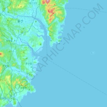
Name: Dong-gu topographic map, elevation, terrain.
Location: Dong-gu, Ulsan, South Korea (35.33770 129.38300 35.57177 129.72062)
Average elevation: 23 m
Minimum elevation: -2 m
Maximum elevation: 446 m
Other topographic maps
Click on a map to view its topography, its elevation and its terrain.
Dongbu-ri
South Korea > Ulsan > Ulju-gun > Dongbu-ri
Dongbu-ri, Ulju-gun, Ulsan, 44953, South Korea
Average elevation: 119 m
Mugeo-dong
South Korea > Ulsan > Mugeo-dong
Mugeo-dong, Nam-gu, Ulsan, 680749, South Korea
Average elevation: 94 m