
Burnside Island topographic map
Interactive map
Click on the map to display elevation.
About this map
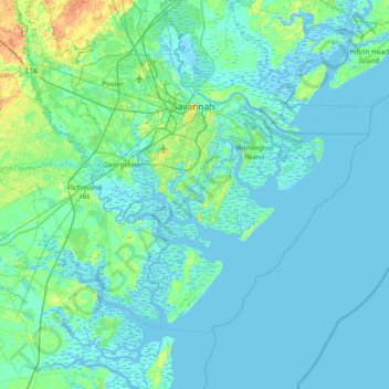
Name: Burnside Island topographic map, elevation, terrain.
Average elevation: 4 m
Minimum elevation: -5 m
Maximum elevation: 30 m
Other topographic maps
Click on a map to view its topography, its elevation and its terrain.
Savannah
United States > Georgia > Chatham County
Savannah, Chatham County, Georgia, United States
Average elevation: 4 m
Tybee Island
United States > Georgia > Chatham County
Tybee Island, Chatham County, Georgia, 31328, United States
Average elevation: 1 m
Skidaway Island
United States > Georgia > Chatham County
Skidaway Island, Chatham County, Georgia, 31411, United States
Average elevation: 3 m
Fort Pulaski
United States > Georgia > Chatham County
Fort Pulaski, Fort Perimeter Trail, Chatham County, Georgia, 31328, United States
Average elevation: 1 m
Pooler
United States > Georgia > Chatham County
Pooler, Chatham County, Georgia, 31322, United States
Average elevation: 7 m
Wilmington Island
United States > Georgia > Chatham County > Wilmington Island
Wilmington Island, Chatham County, Georgia, 31410, United States
Average elevation: 3 m
Grimball Park
United States > Georgia > Chatham County > Isle of Hope
Grimball Park, Isle of Hope, Chatham County, Georgia, 31406, United States
Average elevation: 6 m
Whitemarsh Island
United States > Georgia > Chatham County > Whitemarsh Island
Whitemarsh Island, Chatham County, Georgia, 31410, United States
Average elevation: 4 m
Colonial Oaks
United States > Georgia > Chatham County > Savannah
Colonial Oaks, Savannah, Chatham County, Georgia, 31419, United States
Average elevation: 7 m
Lynhurst
United States > Georgia > Chatham County > Savannah
Lynhurst, Savannah, Chatham County, Georgia, 31406, United States
Average elevation: 8 m
Wilmington Island
United States > Georgia > Chatham County
Wilmington Island, Chatham County, Georgia, 31410, United States
Average elevation: 3 m
Dutch Island
United States > Georgia > Chatham County > Dutch Island
Dutch Island, Chatham County, Georgia, 31410, United States
Average elevation: 4 m
Daffin Park
United States > Georgia > Chatham County > Savannah
Daffin Park, Savannah, Chatham County, Georgia, United States
Average elevation: 9 m
Orleans Square
United States > Georgia > Chatham County > Savannah
Orleans Square, Savannah Historic District, Savannah, Chatham County, Georgia, United States
Average elevation: 9 m
Woodlawn Terrace
United States > Georgia > Chatham County > Garden City
Woodlawn Terrace, Garden City, Chatham County, Georgia, 31408, United States
Average elevation: 7 m
Port Wentworth
United States > Georgia > Chatham County
Port Wentworth, Chatham County, Georgia, 31407, United States
Average elevation: 4 m
Tranquilla Woods
United States > Georgia > Chatham County > Savannah > Tranquilla Woods
Tranquilla Woods, Savannah, Chatham County, Georgia, 31409, United States
Average elevation: 10 m
Welwood
United States > Georgia > Chatham County > Savannah > Welwood
Welwood, Savannah, Chatham County, Georgia, 31409, United States
Average elevation: 7 m
Fig Island
United States > Georgia > Chatham County > Savannah
Fig Island, Savannah, Chatham County, Georgia, 31414, United States
Average elevation: 5 m
DeRenne Terrace
United States > Georgia > Chatham County > Savannah
DeRenne Terrace, Savannah, Chatham County, Georgia, 31404, United States
Average elevation: 7 m
Talahi Island
United States > Georgia > Chatham County > Talahi Island
Talahi Island, Chatham County, Georgia, 31410, United States
Average elevation: 4 m
Ottawa Estates
United States > Georgia > Chatham County > Bloomingdale > Ottawa Estates
Ottawa Estates, Bloomingdale, Chatham County, Georgia, 31302, United States
Average elevation: 8 m
Oakdale
United States > Georgia > Chatham County > Savannah
Oakdale, Savannah, Chatham County, Georgia, 31406, United States
Average elevation: 10 m
Thunderbolt
United States > Georgia > Chatham County
Thunderbolt, Chatham County, Georgia, United States
Average elevation: 5 m
Savannah Beach
United States > Georgia > Chatham County > Tybee Island > Savannah Beach
Savannah Beach, Tybee Island, Chatham County, Georgia, 31328, United States
Average elevation: 1 m
Port Wentworth Junction
United States > Georgia > Chatham County > Savannah > Port Wentworth Junction
Port Wentworth Junction, Savannah, Chatham County, Georgia, 31418, United States
Average elevation: 7 m
Isle of Hope
United States > Georgia > Chatham County
Isle of Hope, Chatham County, Georgia, 31406, United States
Average elevation: 4 m